
Faire un don
Équipez-vous pour votre prochaine aventure :
En tant que Partenaire Amazon, ce site perçoit une commission sur les achats éligibles sans surcoût pour vous.
Carte topographique Tirur
Cliquez sur la carte pour afficher l’altitude.
Faire un don
Équipez-vous pour votre prochaine aventure :
En tant que Partenaire Amazon, ce site perçoit une commission sur les achats éligibles sans surcoût pour vous.
Tirur
Tirur is a Town and municipality in Malappuram district in the Indian state of Kerala spread over an area of 62.34 square kilometres (24.07 sq mi). It is one of the business centers of Malappuram district and is situated 26 kilometres (16 mi) west of Malappuram and 52.5 kilometres (32.6 mi) south of Kozhikode, on the Shoranur–Mangalore section of the Mangalore–Chennai railway line. Tirur is also a major regional trading centre for fish and betel leaf and has an average elevation of 2 metres (6 ft 7 in).
Faire un don
Équipez-vous pour votre prochaine aventure :
En tant que Partenaire Amazon, ce site perçoit une commission sur les achats éligibles sans surcoût pour vous.
À propos de cette carte
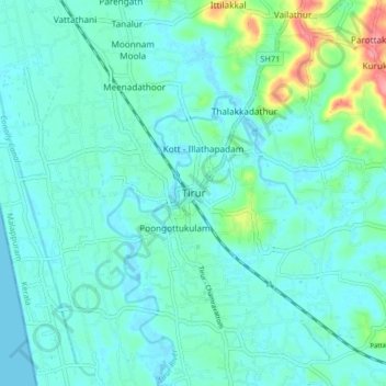
Nom : Carte topographique Tirur, altitude, relief.
Lieu : Tirur, Malappuram, Kerala, 676101, India (10.87668 75.88399 10.95668 75.96399)
Altitude moyenne : 15 m
Altitude minimum : -2 m
Altitude maximum : 88 m
Faire un don
Équipez-vous pour votre prochaine aventure :
En tant que Partenaire Amazon, ce site perçoit une commission sur les achats éligibles sans surcoût pour vous.
Autres cartes topographiques
Cliquez sur une carte pour visualiser sa topographie, son altitude et son relief.
Faire un don
Équipez-vous pour votre prochaine aventure :
En tant que Partenaire Amazon, ce site perçoit une commission sur les achats éligibles sans surcoût pour vous.