
Carte topographique Saratoga County
Carte interactive
Cliquez sur la carte pour afficher l’altitude.
À propos de cette carte
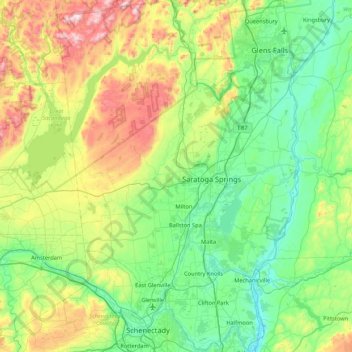
Nom : Carte topographique Saratoga County, altitude, relief.
Lieu : Saratoga County, New York, USA (42.77546 -74.16010 43.39797 -73.57327)
Altitude moyenne : 218 m
Altitude minimum : 3 m
Altitude maximum : 833 m
Autres cartes topographiques
Cliquez sur une carte pour visualiser sa topographie, son altitude et son relief.
Staten Island
Staten Island, Richmond County, New York, USA
Altitude moyenne : 11 m
Chestnut Creek
Chestnut Creek, Town of Neversink, Sullivan County, New York, 12765, USA
Altitude moyenne : 470 m
Gooseberry Hill
Gooseberry Hill, Essex County, New York, 12872, USA
Altitude moyenne : 304 m
City of Saratoga Springs
USA > New York > City of Saratoga Springs
City of Saratoga Springs, Saratoga County, New York, USA
Altitude moyenne : 95 m
Mount Warren
Mount Warren, Town of Bovina, Delaware County, New York, USA
Altitude moyenne : 677 m
West Bay Shore
USA > New York > West Bay Shore
West Bay Shore, Suffolk County, New York, USA
Altitude moyenne : 7 m
Roosevelt Island
USA > New York > New York City
Roosevelt Island, Manhattan Community Board 8, New York County, New York City, New York, 10044, USA
Altitude moyenne : 13 m
Adirondack
USA > New York > Adirondack
Adirondack, Town of Horicon, Warren County, New York, 12808, USA
Altitude moyenne : 294 m
Big Bear Mountain
Big Bear Mountain, Town of Johnsburg, Warren County, New York, USA
Altitude moyenne : 616 m
Niagara Falls
USA > New York > Niagara Falls
Niagara Falls, Niagara County, New York, USA
Altitude moyenne : 180 m
Avalanche Lake
Avalanche Lake, Avalanche Pass Trail, Essex County, New York, USA
Altitude moyenne : 1’066 m
Livingston Island
Livingston Island, Town of Philipstown, Putnam County, New York, 10922, USA
Altitude moyenne : 156 m