
Carte topographique Damavand
Carte interactive
Cliquez sur la carte pour afficher l’altitude.
Damavand
Mount Damavand (Persian: دماوند [dæmɒːvænd] (listen)) is a potentially active stratovolcano, the highest peak in Iran and Western Asia and the highest volcano in Asia and the 2nd highest volcano in the Eastern Hemisphere (after Mount Kilimanjaro), at an elevation of 5,671 metres (18,606 ft). Damāvand has a special place in Persian mythology and folklore. It is in the middle of the Alborz range, adjacent to Varārū, Sesang, Gol-e Zard, and Mīānrūd. It is near the southern coast of the Caspian Sea, in Amol County, Mazandaran Province, 66 km (41 mi) northeast of the city of Tehran.
À propos de cette carte
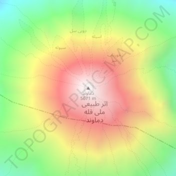
Nom : Carte topographique Damavand, altitude, relief.
Altitude moyenne : 4’949 m
Altitude minimum : 4’345 m
Altitude maximum : 5’595 m
Autres cartes topographiques
Cliquez sur une carte pour visualiser sa topographie, son altitude et son relief.
دهستان لاریجان سفلی
Iran > Mazandaran Province > Amol County > دهستان لاریجان سفلی
Altitude moyenne : 2’569 m