
Carte topographique Somersworth
Carte interactive
Cliquez sur la carte pour afficher l’altitude.
À propos de cette carte
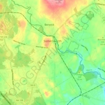
Nom : Carte topographique Somersworth, altitude, relief.
Altitude moyenne : 56 m
Altitude minimum : 8 m
Altitude maximum : 120 m
According to the United States Census Bureau, the city has a total area of 10.0 square miles (25.9 km2), of which 9.8 square miles (25.4 km2) are land and 0.2 square miles (0.5 km2) are water, comprising 1.96% of the city. Somersworth is bordered to the northeast by the Salmon Falls River, which is also the state boundary with Maine. The highest point in Somersworth is Prospect Hill rising just west of the city center, on which the city reservoir is built. The hill's elevation is approximately 310 feet (94 m) above sea level.
Autres cartes topographiques
Cliquez sur une carte pour visualiser sa topographie, son altitude et son relief.
Dover
United States > New Hampshire > Strafford County
Dover, Strafford County, New Hampshire, 03820, United States
Altitude moyenne : 31 m
Rochester
United States > New Hampshire > Strafford County
Rochester, Strafford County, New Hampshire, United States
Altitude moyenne : 90 m
New Durham
United States > New Hampshire > Strafford County
New Durham, Strafford County, New Hampshire, 03855, United States
Altitude moyenne : 228 m
Barrington
United States > New Hampshire > Strafford County
Barrington, Strafford County, New Hampshire, United States
Altitude moyenne : 93 m
Hornetown
United States > New Hampshire > Strafford County > Farmington
Hornetown, Farmington, Strafford County, New Hampshire, United States
Altitude moyenne : 225 m
Dover
United States > New Hampshire > Strafford County > Dover
Dover, Strafford County, New Hampshire, 03820, United States
Altitude moyenne : 52 m
Middleton
United States > New Hampshire > Strafford County
Middleton, Strafford County, New Hampshire, 03887, United States
Altitude moyenne : 233 m
Milton
United States > New Hampshire > Strafford County
Milton, Strafford County, New Hampshire, United States
Altitude moyenne : 183 m
Madbury
United States > New Hampshire > Strafford County
Madbury, Strafford County, New Hampshire, 03823, United States
Altitude moyenne : 34 m
Farmington
United States > New Hampshire > Strafford County
Farmington, Strafford County, New Hampshire, 03835, United States
Altitude moyenne : 168 m
Piper Mountain
United States > New Hampshire > Strafford County > Middleton
Piper Mountain, Middleton, Strafford County, New Hampshire, 03887, United States
Altitude moyenne : 216 m
Rochester
United States > New Hampshire > Strafford County > Rochester
Rochester, Strafford County, New Hampshire, 03867, United States
Altitude moyenne : 118 m
Strafford
United States > New Hampshire > Strafford County
Strafford, Strafford County, New Hampshire, United States
Altitude moyenne : 202 m
Durham
United States > New Hampshire > Strafford County
Durham, Strafford County, New Hampshire, 03824, United States
Altitude moyenne : 23 m