
Carte topographique Gaurikund
Carte interactive
Cliquez sur la carte pour afficher l’altitude.
À propos de cette carte
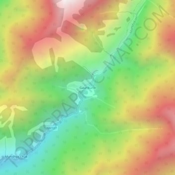
Nom : Carte topographique Gaurikund, altitude, relief.
Lieu : Gaurikund, Ukhimath, Rudraprayag, Uttarakhand, India (30.63340 79.00682 30.67340 79.04682)
Altitude moyenne : 2’589 m
Altitude minimum : 1’749 m
Altitude maximum : 3’559 m
Autres cartes topographiques
Cliquez sur une carte pour visualiser sa topographie, son altitude et son relief.
Dilmi
India > Uttarakhand > Ukhimath > Sari
Dilmi, Sari, Ukhimath, Rudraprayag District, Uttarakhand, 246469, India
Altitude moyenne : 1’898 m
Kedarnath
India > Uttarakhand > Ukhimath
Kedarnath, Ukhimath, Rudraprayag District, Uttarakhand, India
Altitude moyenne : 4’219 m
Uthind
India > Uttarakhand > Ukhimath
Uthind, Ukhimath, Rudraprayag, Uttarakhand, 246419, India
Altitude moyenne : 1’601 m
Sitapur
India > Uttarakhand > Ukhimath > Sitapur
Sitapur, Ukhimath, Rudraprayag, Uttarakhand, 246471, India
Altitude moyenne : 2’062 m
Budha Madmaheshwar
India > Uttarakhand > Ukhimath > Budha Madmaheshwar
Budha Madmaheshwar, Ukhimath, Rudraprayag, Uttarakhand, India
Altitude moyenne : 3’045 m
Sonprayag
India > Uttarakhand > Ukhimath > Sonprayag
Sonprayag, Ukhimath, Rudraprayag, Uttarakhand, 246471, India
Altitude moyenne : 2’053 m
Madmaheshwar
India > Uttarakhand > Ukhimath > Madmaheshwar
Madmaheshwar, Ukhimath, Rudraprayag, Uttarakhand, India
Altitude moyenne : 3’160 m
Chopta Chatti
India > Uttarakhand > Ukhimath > Chopta Chatti
Chopta Chatti, Ukhimath, Rudraprayag, Uttarakhand, India
Altitude moyenne : 2’759 m
Rānsi
India > Uttarakhand > Ukhimath > Rānsi
Rānsi, Ukhimath, Rudraprayag, Uttarakhand, India
Altitude moyenne : 2’054 m