Géolocaliser

Carte topographique Merrill

Carte interactive

Cliquez sur la carte pour afficher l’altitude.

À propos de cette carte

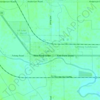
Nom : Carte topographique Merrill, altitude, relief.

Lieu : Merrill, Klamath County, Oregon, United States (42.02142 -121.61291 42.02954 -121.58868)

Altitude moyenne : 1’241 m

Altitude minimum : 1’236 m

Altitude maximum : 1’244 m

Merrill is at an elevation of 4,071 feet (1,241 m) in southern Klamath County, near the Oregon–California border. It is along Oregon Route 39 southeast of Klamath Falls and northwest of Tulelake. Lower Klamath Lake and Tule Lake, both in California, are slightly south of Merrill. By highway, the city is 20 miles (32 km) from Klamath Falls and 300 miles (480 km) from Portland.

Wikipedia (CC-BY-SA 3.0)

Autres cartes topographiques

Cliquez sur une carte pour visualiser sa topographie, son altitude et son relief.

Klamath Falls

United States > Oregon > Klamath County

Klamath Falls, Klamath County, Oregon, 97601, United States

Altitude moyenne : 1’312 m

Dairy

United States > Oregon > Klamath County

Dairy, Klamath County, Oregon, 97625, United States

Altitude moyenne : 1’300 m

Crater Lake National Park

United States > Oregon > Klamath County

Crater Lake National Park, Klamath County, Oregon, 97604, United States

Altitude moyenne : 1’726 m

Rock Point

United States > Oregon > Klamath County

Rock Point, Klamath County, Oregon, 97731, United States

Altitude moyenne : 1’415 m

Altamont

United States > Oregon > Klamath County

Altamont, Klamath County, Oregon, 97603, United States

Altitude moyenne : 1’310 m

Lake of the Woods

United States > Oregon > Klamath County

Lake of the Woods, Klamath County, Oregon, United States

Altitude moyenne : 1’588 m

Chemult

United States > Oregon > Klamath County

Chemult, Klamath County, Oregon, United States

Altitude moyenne : 1’480 m

Crescent

United States > Oregon > Klamath County

Crescent, Klamath County, Oregon, United States

Altitude moyenne : 1’389 m

Sprague River

United States > Oregon > Klamath County

Sprague River, Klamath County, Oregon, 97639, United States

Altitude moyenne : 1’472 m

Malin

United States > Oregon > Klamath County

Malin, Klamath County, Oregon, United States

Altitude moyenne : 1’241 m

Altamont

United States > Oregon > Klamath County > Altamont

Altamont, Klamath County, Oregon, 97603, United States

Altitude moyenne : 1’285 m

Mount Scott

United States > Oregon > Klamath County

Mount Scott, Klamath County, Oregon, United States

Altitude moyenne : 2’295 m

Fort Klamath

United States > Oregon > Klamath County

Fort Klamath, Klamath County, Oregon, United States

Altitude moyenne : 1’273 m

Chiloquin

United States > Oregon > Klamath County

Chiloquin, Klamath County, Oregon, United States

Altitude moyenne : 1’302 m

Beatty

United States > Oregon > Klamath County

Beatty, Klamath County, Oregon, 97602, United States

Altitude moyenne : 1’330 m

Odell Lake

United States > Oregon > Klamath County > Odell Lake

Odell Lake, Klamath County, Oregon, United States

Altitude moyenne : 1’492 m

Crater Lake

United States > Oregon > Klamath County

Crater Lake, Klamath County, Oregon, United States

Altitude moyenne : 1’971 m

Bonanza

United States > Oregon > Klamath County

Bonanza, Klamath County, Oregon, United States

Altitude moyenne : 1’263 m

Keno

United States > Oregon > Klamath County

Keno, Klamath County, Oregon, 97627, United States

Altitude moyenne : 1’287 m

Mount Mazama

United States > Oregon > Klamath County

Mount Mazama, Klamath County, Oregon, United States

Altitude moyenne : 1’880 m