
Faire un don
Équipez-vous pour votre prochaine aventure :
En tant que Partenaire Amazon, ce site perçoit une commission sur les achats éligibles sans surcoût pour vous.
Carte topographique Chester
Cliquez sur la carte pour afficher l’altitude.
Faire un don
Équipez-vous pour votre prochaine aventure :
En tant que Partenaire Amazon, ce site perçoit une commission sur les achats éligibles sans surcoût pour vous.
Chester
Lake Elwell, 15 miles (24 km) southwest of Chester, offer opportunities for boating, skiing, camping, picnicking, and both freshwater fishing and ice fishing. Fishing and floating are also available on the Marias River downstream from Tiber Dam. The Sweet Grass Hills to the north are the highest elevation peaks east of Glacier Park within 30 miles (48 km) of Highway 2. Hunting for deer, antelope, game birds, and elk is popular in the fall.
Faire un don
Équipez-vous pour votre prochaine aventure :
En tant que Partenaire Amazon, ce site perçoit une commission sur les achats éligibles sans surcoût pour vous.
À propos de cette carte
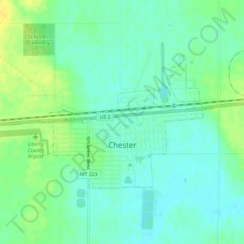
Nom : Carte topographique Chester, altitude, relief.
Lieu : Chester, Liberty County, Montana, 59522, United States (48.50549 -110.97888 48.52014 -110.95384)
Altitude moyenne : 959 m
Altitude minimum : 950 m
Altitude maximum : 972 m
Faire un don
Équipez-vous pour votre prochaine aventure :
En tant que Partenaire Amazon, ce site perçoit une commission sur les achats éligibles sans surcoût pour vous.