Géolocaliser

Carte topographique Gaja

Carte interactive

Cliquez sur la carte pour afficher l’altitude.

À propos de cette carte

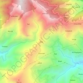
Nom : Carte topographique Gaja, altitude, relief.

Lieu : Gaja, Narendra Nagar, Tehri Garhwal, Uttarakhand, India (30.24896 78.40226 30.28896 78.44226)

Altitude moyenne : 1’599 m

Altitude minimum : 1’009 m

Altitude maximum : 2’177 m

Autres cartes topographiques

Cliquez sur une carte pour visualiser sa topographie, son altitude et son relief.

Byasi

India > Uttarakhand > Narendra Nagar

Byasi, Narendra Nagar, Tehri Garhwal District, Uttarakhand, India

Altitude moyenne : 712 m

Dhalwala park

India > Uttarakhand > Narendra Nagar

Dhalwala park, Dhalwala,Rishikesh,Uttarakhand 249201, Dhalwala, Narendra Nagar, Tehri Garhwal District, Uttarakhand, 249201, India

Altitude moyenne : 390 m

Agrakhal

India > Uttarakhand > Narendra Nagar

Agrakhal, Narendra Nagar, Tehri Garhwal, Uttarakhand, 249175, India

Altitude moyenne : 1’265 m

Narendranagar

India > Uttarakhand > Narendra Nagar

Narendranagar, Narendra Nagar, Tehri Garhwal, Uttarakhand, 249175, India

Altitude moyenne : 851 m