
Carte topographique JATWARA
Carte interactive
Cliquez sur la carte pour afficher l’altitude.
À propos de cette carte
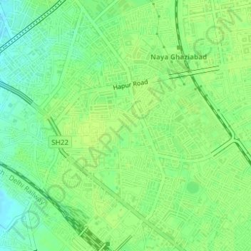
Nom : Carte topographique JATWARA, altitude, relief.
Lieu : JATWARA, Ghaziabad, Uttar Pradesh, 201001, India (28.65598 77.42126 28.67598 77.44126)
Altitude moyenne : 215 m
Altitude minimum : 206 m
Altitude maximum : 218 m
Autres cartes topographiques
Cliquez sur une carte pour visualiser sa topographie, son altitude et son relief.
Indirapuram
India > Uttar Pradesh > Ghaziabad
Indirapuram, Ghaziabad, Uttar Pradesh, 201001, India
Altitude moyenne : 204 m
B Block Park Ramprastha Colony
India > Uttar Pradesh > Ghaziabad
B Block Park Ramprastha Colony, Chander Nagar, Kaushambi, Ghaziabad, Uttar Pradesh, 201001, India
Altitude moyenne : 206 m
Teacher Colony
India > Uttar Pradesh > Ghaziabad
Teacher Colony, Ghaziabad, Uttar Pradesh, 201001, India
Altitude moyenne : 208 m
Patel Nagar
India > Uttar Pradesh > Ghaziabad
Patel Nagar, Ghaziabad, Uttar Pradesh, 201001, India
Altitude moyenne : 212 m