
Faire un don
Équipez-vous pour votre prochaine aventure :
En tant que Partenaire Amazon, ce site perçoit une commission sur les achats éligibles sans surcoût pour vous.
Carte topographique Jinka
Cliquez sur la carte pour afficher l’altitude.
Faire un don
Équipez-vous pour votre prochaine aventure :
En tant que Partenaire Amazon, ce site perçoit une commission sur les achats éligibles sans surcoût pour vous.
Jinka
Jinka is a market town in southern Ethiopia. Located in the hills north of the Tama Plains, this town is the capital of the Debub Omo Zone of the Southern Nations, Nationalities, and Peoples Region. Currently Jinka is the center of Jinka town administration. Jinka has a latitude and longitude of 5°47′N 36°34′E / 5.783°N 36.567°E / 5.783; 36.567 and an elevation of 1490 meters above sea level. It is one of the most famous tourist destinations in the country. It is also an important center for at least sixteen indigenous ethnic groups as well as others from the rest of the country.
Faire un don
Équipez-vous pour votre prochaine aventure :
En tant que Partenaire Amazon, ce site perçoit une commission sur les achats éligibles sans surcoût pour vous.
À propos de cette carte
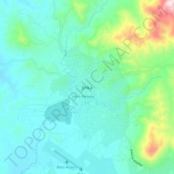
Nom : Carte topographique Jinka, altitude, relief.
Lieu : Jinka, South Omo, South Ethiopia Regional State, Ethiopia (5.74599 36.52518 5.82599 36.60518)
Altitude moyenne : 1’478 m
Altitude minimum : 1’325 m
Altitude maximum : 2’107 m
Faire un don
Équipez-vous pour votre prochaine aventure :
En tant que Partenaire Amazon, ce site perçoit une commission sur les achats éligibles sans surcoût pour vous.
Autres cartes topographiques
Cliquez sur une carte pour visualiser sa topographie, son altitude et son relief.
Nech Sar National Park
Ethiopia > South Ethiopia Regional State > Arba Minch
Altitude moyenne : 1’215 m
Bombe
Ethiopia > South Ethiopia Regional State
Bombe (Geʽez: ቦምቤ) is a town and separate district in Wolayita Zone of the South Ethiopia Regional State, Ethiopia. Bombe town is located 325 km (202 mi) and 55 km (34 mi) away from Addis Ababa and Wolaita Sodo town through Hossana exit, respectively. Bombe town is used as an administrative capital of…
Altitude moyenne : 1’517 m
Boditi
Ethiopia > South Ethiopia Regional State
Boditi, (Amharic: ቦዲቲ) or (Wolayttattuwa: Bodditte) is a city and separate district in south central Ethiopia. The city is located in the Wolaita Zone of the South Ethiopia Regional State. This city has a latitude and longitude of 6°58′N 37°52′E / 6.967°N 37.867°E / 6.967; 37.867 with an…
Altitude moyenne : 1’982 m