
Carte topographique Hameau Aloyse Merkling
Carte interactive
Cliquez sur la carte pour afficher l’altitude.
À propos de cette carte
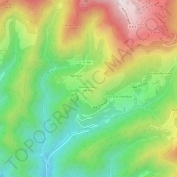
Nom : Carte topographique Hameau Aloyse Merkling, altitude, relief.
Altitude moyenne : 773 m
Altitude minimum : 418 m
Altitude maximum : 1’259 m
Autres cartes topographiques
Cliquez sur une carte pour visualiser sa topographie, son altitude et son relief.
Großer Belchen
Frankreich > Grand Est > Oberelsass > Goldbach-Altenbach
Großer Belchen, Goldbach-Altenbach, Thann-Gebweiler, Oberelsass, Grand Est, Metropolitanes Frankreich, 68760, Frankreich
Altitude moyenne : 1’139 m