
Carte topographique Eghlid
Carte interactive
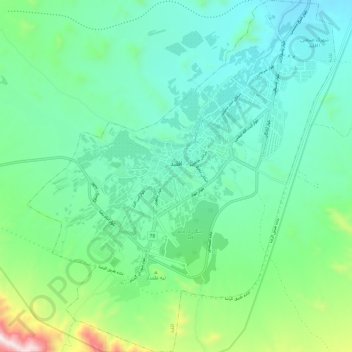
Cliquez sur la carte pour afficher l’altitude.
À propos de cette carte
Nom : Carte topographique Eghlid, altitude, relief.
Altitude moyenne : 2’310 m
Altitude minimum : 2’115 m
Altitude maximum : 2’984 m
Eqlid is located 22 km west of the Expressway between Isfahan and Shiraz. The population of Eghlid is about 45,000 (2011). It is located close to the mountain chain Zagros and is one of the highest elevations (a mountain peak known as Bel) among Iran cities (2250 meters). It is also close to the desert city of Abarqu, making it a city in the border of high mountain and desert. It has a dry and cold weather, and some of its mountain peaks are covered by snow throughout the year. It is an agriculture city and its main products are wheat, barley, potato and fruits like grapes, walnut, apple, and pear. Its main road is Emam Khomeini Boulevard.
Autres cartes topographiques
Cliquez sur une carte pour visualiser sa topographie, son altitude et son relief.
Dordaneh
Iran > Fars Province > Eqlid County > Ahmadabad RD
Dordaneh, Ahmadabad RD, Hasanabad District, Eqlid County, Fars Province, Iran
Altitude moyenne : 2’236 m