
Carte topographique Aswan Low Dam (Khazzan Aswan)
Carte interactive
Cliquez sur la carte pour afficher l’altitude.
À propos de cette carte
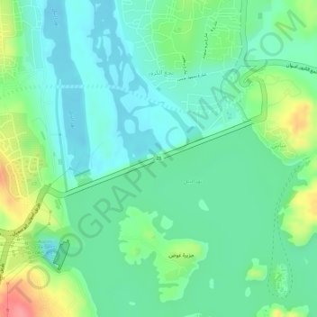
Nom : Carte topographique Aswan Low Dam (Khazzan Aswan), altitude, relief.
Lieu : Aswan Low Dam (Khazzan Aswan), Shash, Aswan, Egypt (24.03248 32.86402 24.03880 32.88145)
Altitude moyenne : 113 m
Altitude minimum : 84 m
Altitude maximum : 176 m
The Aswan Low Dam or Old Aswan Dam is a gravity masonry buttress dam on the Nile River in Aswan, Egypt. The dam was built by the British at the former first cataract of the Nile, and is located about 1000 km up-river and 690 km (direct distance) south-southeast of Cairo. When initially constructed between 1899 and 1902, nothing of its scale had ever been attempted; on completion, it was the largest masonry dam in the world. The dam was designed to provide storage of annual floodwater and augment dry season flows to support greater irrigation development and population growth in the lower Nile. The dam, originally limited in height by conservation concerns, worked as designed, but provided inadequate storage capacity for planned development and was raised twice: between 1907 and 1912 and again between 1929 and 1933. These heightenings still did not meet irrigation demands and in 1946 it was nearly over-topped in an effort to maximize pool elevation. This led to the investigation and construction of the Aswan High Dam 6 kilometres (3.7 mi) upstream.
Autres cartes topographiques
Cliquez sur une carte pour visualiser sa topographie, son altitude et son relief.
Jazīrat ‘Awwāḑ
Jazīrat ‘Awwāḑ, Shash, Aswan, 81531, Egypt
Altitude moyenne : 201 m