
Carte topographique Laage
Carte interactive
Cliquez sur la carte pour afficher l’altitude.
À propos de cette carte
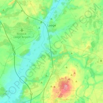
Nom : Carte topographique Laage, altitude, relief.
Altitude moyenne : 39 m
Altitude minimum : 8 m
Altitude maximum : 127 m
To the west and east of the Recknitz-Urstromtal there are terminal moraines. Der Kalte Berg is 62m above the Normalhöhennull, the tallest point of elevation in the municipal area. Rostock Laage Airport is located a few kilometers west of Laage.
Autres cartes topographiques
Cliquez sur une carte pour visualiser sa topographie, son altitude et son relief.
Teterow
Germany > Mecklenburg-Vorpommern > Landkreis Rostock
Teterow, Landkreis Rostock, Mecklenburg-Vorpommern, 17166, Germany
Altitude moyenne : 39 m
Tarnow
Germany > Mecklenburg-Vorpommern > Landkreis Rostock
Tarnow, Bützow-Land, Landkreis Rostock, Mecklenburg-Vorpommern, Germany
Altitude moyenne : 26 m
Laage
Germany > Mecklenburg-Vorpommern > Landkreis Rostock > Laage > Laage
Laage, Landkreis Rostock, Mecklenburg-Vorpommern, 18299, Germany
Altitude moyenne : 33 m
Laage
Germany > Mecklenburg-Vorpommern > Landkreis Rostock > Laage
Laage, Landkreis Rostock, Mecklenburg-Vorpommern, 18299, Germany
Altitude moyenne : 37 m