
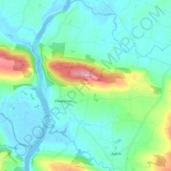
Carte topographique Dromana
Carte interactive
Cliquez sur la carte pour afficher l’altitude.
À propos de cette carte
Nom : Carte topographique Dromana, altitude, relief.
Altitude moyenne : 34 m
Altitude minimum : -14 m
Altitude maximum : 148 m
Autres cartes topographiques
Cliquez sur une carte pour visualiser sa topographie, son altitude et son relief.
Kilsheelan Registrars District 1885
Kilsheelan Registrars District 1885, County Waterford, Munster, Ireland
Altitude moyenne : 160 m
The Municipal District of Dungarvan — Lismore
The Municipal District of Dungarvan — Lismore, County Waterford, Munster, Ireland
Altitude moyenne : 120 m
Newtown Cove
Newtown Cove, Islandikane, Waterford City Metropolitan District, County Waterford, Munster, Ireland
Altitude moyenne : 22 m
Skibbereen
Skibbereen, Ballynaneashagh, Waterford City Metropolitan District, County Waterford, Munster, Ireland
Altitude moyenne : 40 m
Ballynaharda
Ballynaharda, Ballymacart, The Municipal District of Dungarvan — Lismore, County Waterford, Munster, Ireland
Altitude moyenne : 50 m
Comeragh
Comeragh, The Municipal District of Comeragh, County Waterford, Munster, Ireland
Altitude moyenne : 215 m
Waterford
Waterford, County Waterford, Munster, Ireland
Altitude moyenne : 33 m
Waterford City Metropolitan District
Waterford City Metropolitan District, County Waterford, Munster, Ireland
Altitude moyenne : 29 m
Tallow
Tallow, The Municipal District of Dungarvan — Lismore, County Waterford, Munster, Ireland
Altitude moyenne : 105 m
Ballymacarbry
Ballymacarbry, The Municipal District of Comeragh, County Waterford, Munster, Ireland
Altitude moyenne : 145 m
Ballyduff
Ballyduff, The Municipal District of Dungarvan — Lismore, County Waterford, Munster, Ireland
Altitude moyenne : 187 m
Tramore
Tramore, Waterford City Metropolitan District, County Waterford, Munster, Ireland
Altitude moyenne : 41 m