
Faire un don
Équipez-vous pour votre prochaine aventure :
En tant que Partenaire Amazon, ce site perçoit une commission sur les achats éligibles sans surcoût pour vous.
Carte topographique Palangka Raya
Cliquez sur la carte pour afficher l’altitude.
Faire un don
Équipez-vous pour votre prochaine aventure :
En tant que Partenaire Amazon, ce site perçoit une commission sur les achats éligibles sans surcoût pour vous.
Palangka Raya
Palangka Raya borders Gunung Mas Regency to the north, Katingan Regency to the west, and Pulang Pisau Regency to the south and east. The area's soil consists mostly of peat and alluvium in its southern part and podzol on the northern part of the city. Overall, podzol soil dominates the city soil with 218,486 out of 285,349 hectares of city's landscape. Most of the city's topography is flat, with a general slope of less than 40 percent. Palangka Raya is mostly located around 35 meters above sea level.
Faire un don
Équipez-vous pour votre prochaine aventure :
En tant que Partenaire Amazon, ce site perçoit une commission sur les achats éligibles sans surcoût pour vous.
À propos de cette carte
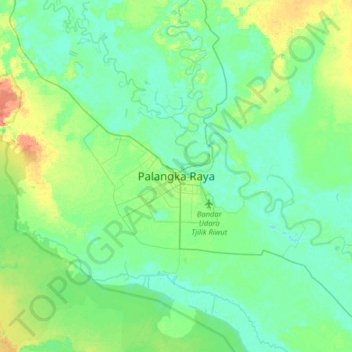
Nom : Carte topographique Palangka Raya, altitude, relief.
Lieu : Palangka Raya, Central Kalimantan, 73112, Indonesia (-2.36729 113.75644 -2.04729 114.07644)
Altitude moyenne : 10 m
Altitude minimum : -3 m
Altitude maximum : 35 m
Faire un don
Équipez-vous pour votre prochaine aventure :
En tant que Partenaire Amazon, ce site perçoit une commission sur les achats éligibles sans surcoût pour vous.