
Carte topographique Mount Elbrus (West Summit)
Carte interactive
Cliquez sur la carte pour afficher l’altitude.
À propos de cette carte
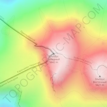
Nom : Carte topographique Mount Elbrus (West Summit), altitude, relief.
Altitude moyenne : 5’164 m
Altitude minimum : 4’572 m
Altitude maximum : 5’632 m
As Elbrus is located in the Northern Hemisphere, the summer period takes place from June to mid-September, with an average of 50% of sunny days favorable to the ascent of the summit. However, the winds, dominated by westerly air masses, can turn violent and temperatures drop very quickly. Above 4000 meters above sea level, even in summer, blizzard conditions with near zero visibility can develop. It is not uncommon for the wind to exceed 100 km/h. In winter, the temperature can drop below −50° at the top. Precipitation increases with altitude.
Autres cartes topographiques
Cliquez sur une carte pour visualiser sa topographie, son altitude et son relief.
Западное ребро
Russia > Karachay-Cherkessia > Karachayevsky District
Западное ребро, Хурзукское сельское поселение, Karachayevsky District, Karachay-Cherkessia, North Caucasian Federal District, Russia
Altitude moyenne : 5’130 m
Западное ребро
Russia > Karachay-Cherkessia > Karachayevsky District
Западное ребро, Хурзукское сельское поселение, Karachayevsky District, Karachay-Cherkessia, North Caucasian Federal District, Russia
Altitude moyenne : 5’057 m