
Carte topographique Rosamond
Carte interactive
Cliquez sur la carte pour afficher l’altitude.
À propos de cette carte
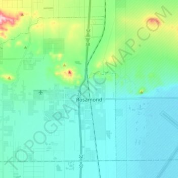
Nom : Carte topographique Rosamond, altitude, relief.
Lieu : Rosamond, Kern County, California, 93560, United States (34.81995 -118.29364 34.92294 -118.14007)
Altitude moyenne : 749 m
Altitude minimum : 691 m
Altitude maximum : 1’011 m
Rosamond sits in the northern end of the Antelope Valley, the westernmost valley of the Mojave Desert. Because the elevation is 2,000 to 3,000 feet (610 to 910 m) above sea level, the area, like the other parts of the Mojave Desert region, is referred to as the High Desert. Some cities and communities within the trading area of Rosamond include Lancaster, Palmdale, Hi Vista, Roosevelt, Redman, Lake Los Angeles, Quartz Hill, Ridgecrest, and Santa Clarita. Residents of these desert cities and unincorporated communities share Sierra Highway, Angeles Forest Highway, Angeles Crest Highway (State Route 2), and the Antelope Valley Freeway (State Route 14) for commutes to the San Fernando Valley and Los Angeles Basin in order to get to work.
Autres cartes topographiques
Cliquez sur une carte pour visualiser sa topographie, son altitude et son relief.
Tehachapi
United States > California > Kern County
Tehachapi, Kern County, California, 93561, United States
Altitude moyenne : 1’414 m
Mojave
United States > California > Kern County
Mojave, Kern County, California, United States
Altitude moyenne : 857 m
Wasco
United States > California > Kern County
Wasco, Kern County, California, United States
Altitude moyenne : 101 m
Cantil
United States > California > Kern County
Cantil, Kern County, California, United States
Altitude moyenne : 628 m
Woodford
United States > California > Kern County
Woodford, El Rita, Kern County, California, 93531, United States
Altitude moyenne : 899 m
City of Shafter
United States > California > Kern County
City of Shafter, Kern County, California, United States
Altitude moyenne : 118 m
Tehachapi Mountain
United States > California > Kern County
Tehachapi Mountain, Kern County, California, United States
Altitude moyenne : 2’142 m
Baker
United States > California > Kern County > Boron
Baker, Boron, Kern County, California, United States
Altitude moyenne : 765 m
Gulf
United States > California > Kern County
Gulf, Kern County, CAL Fire Contract Counties, California, United States
Altitude moyenne : 88 m
Kern City
United States > California > Kern County > Bakersfield
Kern City, Bakersfield, Kern County, CAL Fire Southern Region, California, 93309, United States
Altitude moyenne : 119 m
Golden Hills
United States > California > Kern County > Golden Hills
Golden Hills, Kern County, California, United States
Altitude moyenne : 1’275 m
Onyx
United States > California > Kern County
Onyx, Kern County, California, 93255, United States
Altitude moyenne : 1’205 m
Arvin
United States > California > Kern County
Arvin, Kern County, California, United States
Altitude moyenne : 130 m
California City
United States > California > Kern County
California City, Kern County, California, United States
Altitude moyenne : 845 m
Buttonwillow
United States > California > Kern County > Buttonwillow
Buttonwillow, Kern County, California, 93206, United States
Altitude moyenne : 87 m
Rosedale
United States > California > Kern County
Rosedale, Kern County, CAL Fire Southern Region, California, United States
Altitude moyenne : 107 m
Frazier Park
United States > California > Kern County
Frazier Park, Kern County, California, United States
Altitude moyenne : 1’533 m
Oil City
United States > California > Kern County
Oil City, Kern River Oil Field, Kern County, California, 93305, United States
Altitude moyenne : 162 m
Walong
United States > California > Kern County > Keene
Walong, Keene, Kern County, California, United States
Altitude moyenne : 998 m
McKittrick
United States > California > Kern County
McKittrick, Kern County, California, 93251, United States
Altitude moyenne : 388 m
Taft
United States > California > Kern County > Taft > Taft
Taft, Kern County, California, 93268, United States
Altitude moyenne : 301 m
China Lake
United States > California > Kern County > Ridgecrest > China Lake
China Lake, Ridgecrest, Kern County, California, 93555-2508, United States
Altitude moyenne : 689 m
Goler Heights
United States > California > Kern County > Goler Heights
Goler Heights, Kern County, California, United States
Altitude moyenne : 822 m
Edison
United States > California > Kern County
Edison, Kern County, California, 93303, United States
Altitude moyenne : 178 m
Taft
United States > California > Kern County
Taft, Kern County, California, 93268, United States
Altitude moyenne : 370 m
Pine Mountain Club
United States > California > Kern County
Pine Mountain Club, Kern County, California, 93222, United States
Altitude moyenne : 1’867 m
Rowen
United States > California > Kern County
Rowen, Kern County, California, 93531, United States
Altitude moyenne : 806 m
Bakersfield
United States > California > Kern County
Bakersfield, Kern County, California, United States
Altitude moyenne : 157 m
Edwards Air Force Base
United States > California > Kern County
Edwards Air Force Base, Kern County, California, United States
Altitude moyenne : 730 m
Lebec
United States > California > Kern County
Lebec, Kern County, California, 93243, United States
Altitude moyenne : 1’162 m
Rosedale
United States > California > Kern County
Rosedale, Kern County, California, United States
Altitude moyenne : 113 m
Inyokern
United States > California > Kern County > Inyokern
Inyokern, Kern County, California, United States
Altitude moyenne : 753 m
Kernville
United States > California > Kern County
Kernville, Kern County, California, 93238, United States
Altitude moyenne : 1’135 m