
Faire un don
Équipez-vous pour votre prochaine aventure :
En tant que Partenaire Amazon, ce site perçoit une commission sur les achats éligibles sans surcoût pour vous.
Carte topographique Roopkund Lake
Cliquez sur la carte pour afficher l’altitude.
Faire un don
Équipez-vous pour votre prochaine aventure :
En tant que Partenaire Amazon, ce site perçoit une commission sur les achats éligibles sans surcoût pour vous.
Roopkund Lake
Roopkund (locally known as Mystery Lake or Skeleton Lake) is a high altitude glacial lake in the Uttarakhand state of India. It lies in the lap of Trishul massif. Located in the Himalayas, the area around the lake is uninhabited and is roughly at an altitude of 5,020 metres (16,470 ft), surrounded by rock-strewn glaciers and snow-clad mountains. Roopkund is a popular trekking destination. The size of the lake varies substantially, but it is seldom more than 40 metres in diameter (1000 to 1500 square metres in area), and is frozen in the winter.
Faire un don
Équipez-vous pour votre prochaine aventure :
En tant que Partenaire Amazon, ce site perçoit une commission sur les achats éligibles sans surcoût pour vous.
À propos de cette carte
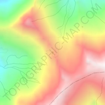
Nom : Carte topographique Roopkund Lake, altitude, relief.
Lieu : Roopkund Lake, Chamoli Tehsil, Chamoli, Uttarakhand, India (30.26174 79.73137 30.26249 79.73200)
Altitude moyenne : 4’631 m
Altitude minimum : 3’974 m
Altitude maximum : 5’200 m
Faire un don
Équipez-vous pour votre prochaine aventure :
En tant que Partenaire Amazon, ce site perçoit une commission sur les achats éligibles sans surcoût pour vous.
Autres cartes topographiques
Cliquez sur une carte pour visualiser sa topographie, son altitude et son relief.
Gopeshwar
India > Uttarakhand > Chamoli Tehsil
Gopeshwar is located at 30°25′N 79°20′E / 30.42°N 79.33°E / 30.42; 79.33. It has an average elevation of 1,450 m (4,760 ft). Gopeshwar is 8.4 km (5.2 mi) away from Chamoli which is located on the banks of Alaknanda river and along NH 58. Gopeshwar is able to captivate any visitor with its…
Altitude moyenne : 1’566 m
Faire un don
Équipez-vous pour votre prochaine aventure :
En tant que Partenaire Amazon, ce site perçoit une commission sur les achats éligibles sans surcoût pour vous.
Gopeshwar
India > Uttarakhand > Chamoli Tehsil
Gopeshwar is located at 30°25′N 79°20′E / 30.42°N 79.33°E / 30.42; 79.33. It has an average elevation of 1,450 m (4,760 ft). Gopeshwar is 8.4 km (5.2 mi) away from Chamoli which is located on the banks of Alaknanda river and along NH 58.
Altitude moyenne : 1’566 m