
Faire un don
Équipez-vous pour votre prochaine aventure :
En tant que Partenaire Amazon, ce site perçoit une commission sur les achats éligibles sans surcoût pour vous.
Carte topographique Tudor
Cliquez sur la carte pour afficher l’altitude.
Faire un don
Équipez-vous pour votre prochaine aventure :
En tant que Partenaire Amazon, ce site perçoit une commission sur les achats éligibles sans surcoût pour vous.
À propos de cette carte
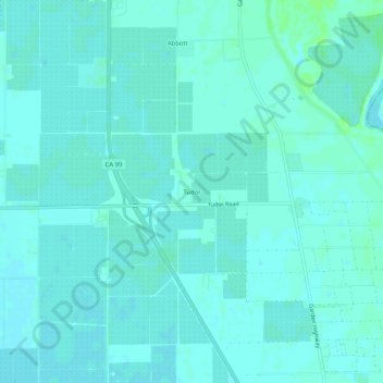
Nom : Carte topographique Tudor, altitude, relief.
Altitude moyenne : 13 m
Altitude minimum : 10 m
Altitude maximum : 19 m
Faire un don
Équipez-vous pour votre prochaine aventure :
En tant que Partenaire Amazon, ce site perçoit une commission sur les achats éligibles sans surcoût pour vous.
Autres cartes topographiques
Cliquez sur une carte pour visualiser sa topographie, son altitude et son relief.
Yuba City
United States > California > Sutter County
On March 14, 1961, a Boeing B-52 Stratofortress carrying nuclear weapons, flying near Yuba City, encountered a pressurization problem, and had to drop to a lower altitude. Because of this, more fuel than expected was used, and the aircraft ran out of fuel. It crashed before meeting with a tanker aircraft. The…
Altitude moyenne : 18 m
Faire un don
Équipez-vous pour votre prochaine aventure :
En tant que Partenaire Amazon, ce site perçoit une commission sur les achats éligibles sans surcoût pour vous.