
Carte topographique Casey
Carte interactive
Cliquez sur la carte pour afficher l’altitude.
À propos de cette carte
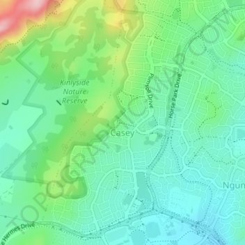
Nom : Carte topographique Casey, altitude, relief.
Altitude moyenne : 660 m
Altitude minimum : 606 m
Altitude maximum : 800 m
Until 1990, Casey was part of the former 'Gold Creek' a 3,940-acre (15.9 km2) rural property with the Gold Creek Homestead at its centre. The relative flat and even topography of portions of the suburb of Casey was ideal for various pursuits including horse racing, and was the site of a practice track for racing horses. A stand of trees parallel to Horse Park Drive which predates the establishment of the village (now the suburb) of Hall marks the original alignment of the Queanbeyan-Yass Road.
Autres cartes topographiques
Cliquez sur une carte pour visualiser sa topographie, son altitude et son relief.
Taylor
Australia > District of Gungahlin
Taylor, District of Gungahlin, Australian Capital Territory, Australia
Altitude moyenne : 693 m
Gubur Dhaura
Australia > District of Gungahlin
Gubur Dhaura, Franklin, District of Gungahlin, Australian Capital Territory, 2913, Australia
Altitude moyenne : 622 m
Bonner
Australia > District of Gungahlin
Bonner, District of Gungahlin, Australian Capital Territory, Australia
Altitude moyenne : 655 m
Throsby
Australia > District of Gungahlin
Throsby, District of Gungahlin, Australian Capital Territory, Australia
Altitude moyenne : 632 m
Ngunnawal
Australia > District of Gungahlin
Ngunnawal, District of Gungahlin, Australian Capital Territory, 2913, Australia
Altitude moyenne : 631 m
Nicholls
Australia > Australian Capital Territory > District of Gungahlin
Nicholls, District of Gungahlin, Australian Capital Territory, Australia
Altitude moyenne : 622 m
Crace
Australia > District of Gungahlin
Crace, District of Gungahlin, Australian Capital Territory, 2911, Australia
Altitude moyenne : 614 m
Forde
Australia > District of Gungahlin
Forde, District of Gungahlin, Australian Capital Territory, Australia
Altitude moyenne : 639 m
Amaroo
Australia > District of Gungahlin
Amaroo, District of Gungahlin, Australian Capital Territory, Australia
Altitude moyenne : 629 m
Palmerston
Australia > District of Gungahlin
Palmerston, District of Gungahlin, Australian Capital Territory, Australia
Altitude moyenne : 615 m
Harrison
Australia > District of Gungahlin
Harrison, District of Gungahlin, Australian Capital Territory, Australia
Altitude moyenne : 620 m
Franklin
Australia > District of Gungahlin
Franklin, District of Gungahlin, Australian Capital Territory, Australia
Altitude moyenne : 616 m
Moncrieff
Australia > District of Gungahlin
Moncrieff, District of Gungahlin, Australian Capital Territory, Australia
Altitude moyenne : 644 m