
Carte topographique Untersiemau
Carte interactive
Cliquez sur la carte pour afficher l’altitude.
À propos de cette carte
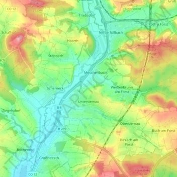
Nom : Carte topographique Untersiemau, altitude, relief.
Lieu : Untersiemau, Landkreis Coburg, Bayern, 96253, Deutschland (50.17322 10.91416 50.22707 11.01104)
Altitude moyenne : 319 m
Altitude minimum : 264 m
Altitude maximum : 405 m
Untersiemau liegt am Ostrand des Itzgrunds etwa zehn Kilometer südlich von Coburg auf einer Höhe von etwa 300 Metern. Östlich des Ortes erstreckt sich der Lichtenfelser Forst.
Autres cartes topographiques
Cliquez sur une carte pour visualiser sa topographie, son altitude et son relief.
Heldritt
Deutschland > Bayern > Landkreis Coburg > Bad Rodach
Heldritt, Bad Rodach, Landkreis Coburg, Bayern, 96476, Deutschland
Altitude moyenne : 374 m
Ahlstadt
Deutschland > Bayern > Landkreis Coburg
Ahlstadt, Meeder, Landkreis Coburg, Bayern, Deutschland
Altitude moyenne : 435 m
Sonnefeld
Deutschland > Bayern > Landkreis Coburg
Sonnefeld, Landkreis Coburg, Bayern, 96242, Deutschland
Altitude moyenne : 354 m
Kleingarnstadt
Deutschland > Bayern > Landkreis Coburg
Kleingarnstadt, Ebersdorf b.Coburg, Landkreis Coburg, Bayern, Deutschland
Altitude moyenne : 385 m
Hattersdorf
Deutschland > Bayern > Landkreis Coburg > Seßlach
Hattersdorf, Seßlach, Landkreis Coburg, Bayern, 96145, Deutschland
Altitude moyenne : 300 m
Bad Rodach
Deutschland > Bayern > Landkreis Coburg
Bad Rodach, Landkreis Coburg, Bayern, 96476, Deutschland
Altitude moyenne : 352 m
Ahorn
Deutschland > Bayern > Landkreis Coburg
Ahorn, Landkreis Coburg, Bayern, 96482, Deutschland
Altitude moyenne : 333 m
Rödental
Deutschland > Bayern > Landkreis Coburg
Rödental, Landkreis Coburg, Bayern, 96472, Deutschland
Altitude moyenne : 381 m
Neustadt bei Coburg
Deutschland > Bayern > Landkreis Coburg
Neustadt bei Coburg, Landkreis Coburg, Bayern, 96465, Deutschland
Altitude moyenne : 372 m
Ebersdorf b.Coburg
Deutschland > Bayern > Landkreis Coburg
Ebersdorf b.Coburg, Landkreis Coburg, Bayern, 96237, Deutschland
Altitude moyenne : 351 m
Hassenberg
Deutschland > Bayern > Landkreis Coburg > Hassenberg
Hassenberg, Sonnefeld, Landkreis Coburg, Bayern, 96268, Deutschland
Altitude moyenne : 338 m
Scherneck
Deutschland > Bayern > Landkreis Coburg
Scherneck, Untersiemau, Landkreis Coburg, Bayern, 96253, Deutschland
Altitude moyenne : 307 m
Grub am Forst
Deutschland > Bayern > Landkreis Coburg > Grub a.Forst > Grub am Forst
Grub am Forst, Grub a.Forst, Grub am Forst (VGem), Landkreis Coburg, Bayern, 96271, Deutschland
Altitude moyenne : 343 m
Itzgrund
Deutschland > Bayern > Landkreis Coburg
Itzgrund, Landkreis Coburg, Bayern, 96274, Deutschland
Altitude moyenne : 307 m
Seßlach
Deutschland > Bayern > Landkreis Coburg
Seßlach, Landkreis Coburg, Bayern, 96145, Deutschland
Altitude moyenne : 325 m
Weitramsdorf
Deutschland > Bayern > Landkreis Coburg
Weitramsdorf, Landkreis Coburg, Bayern, 96479, Deutschland
Altitude moyenne : 341 m
Boderndorf
Deutschland > Bayern > Landkreis Coburg > Neustadt bei Coburg
Boderndorf, Neustadt bei Coburg, Landkreis Coburg, Bayern, 96465, Deutschland
Altitude moyenne : 369 m
Lahm
Deutschland > Bayern > Landkreis Coburg > Ebersdorf b.Coburg
Lahm, Ebersdorf b.Coburg, Landkreis Coburg, Bayern, 96271, Deutschland
Altitude moyenne : 361 m
Meeder
Deutschland > Bayern > Landkreis Coburg
Meeder, Landkreis Coburg, Bayern, 96484, Deutschland
Altitude moyenne : 398 m