
Carte topographique Shrewsbury
Carte interactive
Cliquez sur la carte pour afficher l’altitude.
À propos de cette carte
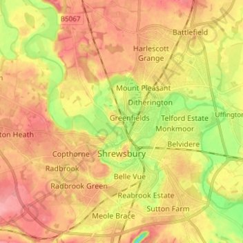
Nom : Carte topographique Shrewsbury, altitude, relief.
Lieu : Shrewsbury, Shropshire, England, United Kingdom (52.68019 -2.81432 52.75498 -2.70122)
Altitude moyenne : 69 m
Altitude minimum : 19 m
Altitude maximum : 103 m
The town centre is partially built on a hill whose elevation is, at its highest, 246 feet (75 m) above sea level. The longest river in the UK, the River Severn, flows through the town, forming a meander around its centre. The Rea Brook is a small river that has its confluence with the Severn at Shrewsbury, just upstream from the English Bridge, and much of the Rea Brook Valley within the town is a country park and local nature reserve, encompassing 36 hectares (89 acres). The town is subject to flooding from these rivers.
Autres cartes topographiques
Cliquez sur une carte pour visualiser sa topographie, son altitude et son relief.
Ellesmere
United Kingdom > England > Shropshire > Ellesmere
Ellesmere, Shropshire, England, SY12 0EQ, United Kingdom
Altitude moyenne : 94 m
Snailbeach
United Kingdom > England > Shropshire
Snailbeach, Shropshire, England, SY5 0NX, United Kingdom
Altitude moyenne : 248 m