
Faire un don
Équipez-vous pour votre prochaine aventure :
En tant que Partenaire Amazon, ce site perçoit une commission sur les achats éligibles sans surcoût pour vous.
Carte topographique Untertheres
Cliquez sur la carte pour afficher l’altitude.
Faire un don
Équipez-vous pour votre prochaine aventure :
En tant que Partenaire Amazon, ce site perçoit une commission sur les achats éligibles sans surcoût pour vous.
À propos de cette carte
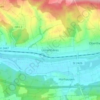
Nom : Carte topographique Untertheres, altitude, relief.
Altitude moyenne : 253 m
Altitude minimum : 212 m
Altitude maximum : 348 m
Faire un don
Équipez-vous pour votre prochaine aventure :
En tant que Partenaire Amazon, ce site perçoit une commission sur les achats éligibles sans surcoût pour vous.
Autres cartes topographiques
Cliquez sur une carte pour visualiser sa topographie, son altitude et son relief.
Haßfurt
Deutschland > Bayern > Landkreis Haßberge
„In einer der lieblichsten Gegenden des an malerischen Schönheiten so reichen Maingrundes, der sich von Bamberg bis Schweinfurt erstreckt, auf einer sanften Anhöhe, hart am rechten Ufer des Mains malerisch hingegossen, liegt das hübsche Städtchen Haßfurt, südlich von den waldigen Bergen des Steigers,…
Altitude moyenne : 267 m
Sand a. Main
Deutschland > Bayern > Landkreis Haßberge
Ein traditioneller Zweig der Landwirtschaft, der Weinbau, ist auch heute noch in Sand lebendig. Die ortsansässigen Winzer bauen an den Berghängen rund um das Dorf ihren Wein an. Das sommerliche Altmain-Weinfest ist der Höhepunkt im Veranstaltungsjahr. Mit mittlerweile etwa 50.000 Besuchern an vier Tagen ist…
Altitude moyenne : 283 m
Knetzgau
Deutschland > Bayern > Landkreis Haßberge
Die Gemeinde liegt am nördlichen Rand des Naturparks Steigerwald auf einer Höhe von etwa 238 m ü. NHN. Sie liegt am Main, etwa fünf Kilometer südöstlich von Haßfurt am Rande der Haßberge.
Altitude moyenne : 306 m
Faire un don
Équipez-vous pour votre prochaine aventure :
En tant que Partenaire Amazon, ce site perçoit une commission sur les achats éligibles sans surcoût pour vous.
Rauhenebrach
Deutschland > Bayern > Landkreis Haßberge
Die Kilianseiche hat einem BHU (Brusthöhenumfang) von 7,20 m. ⊙49.87613110.593019
Altitude moyenne : 381 m
Faire un don
Équipez-vous pour votre prochaine aventure :
En tant que Partenaire Amazon, ce site perçoit une commission sur les achats éligibles sans surcoût pour vous.
Ermershausen
Deutschland > Bayern > Landkreis Haßberge
In Ermershausen waren wahrscheinlich schon im 16. Jahrhundert, spätestens jedoch seit 1648 Juden angesiedelt. Im Jahre 1813 wurden 97 jüdische Einwohner gezählt. Bis 1900 schwankte die Zahl der Juden in Ermershausen bei ca. 90 Einwohnern, mit Höhepunkten in den Jahren 1800 und 1830 mit 126 Personen. Dies…
Altitude moyenne : 368 m
Riedbach
Deutschland > Bayern > Landkreis Haßberge
Die Gemeinde-Schlüsselzuweisung vom Freistaat Bayern für Riedbach als Ausgleich zur Finanzausstattung für das Jahr 2009 betrug 563.016 Euro. Das ist ein Plus in Höhe von 10.800 Euro gegenüber dem Vorjahr 2008, für das ein Betrag in Höhe von 552.216 Euro zugewiesen war, ein Plus von 13,7 Prozent in Höhe…
Altitude moyenne : 340 m
Aidhausen
Deutschland > Bayern > Landkreis Haßberge
Die Gemeindesteuereinnahmen betrugen im Jahr 1999 umgerechnet 610.000 Euro, davon waren 52.000 Euro (netto) Gewerbesteuereinnahmen. Am 30. Juni 2021 gab es 154 sozialversicherungspflichtige Arbeitsplätze in der Gemeinde. Von der Wohnbevölkerung standen 754 Personen in einem versicherungspflichtigen…
Altitude moyenne : 332 m
Faire un don
Équipez-vous pour votre prochaine aventure :
En tant que Partenaire Amazon, ce site perçoit une commission sur les achats éligibles sans surcoût pour vous.
Faire un don
Équipez-vous pour votre prochaine aventure :
En tant que Partenaire Amazon, ce site perçoit une commission sur les achats éligibles sans surcoût pour vous.
Untermerzbach
Deutschland > Bayern > Landkreis Haßberge
Die seit 1963 als Naturdenkmal ausgewiesene Stieleiche mit einem Brusthöhenumfang von 6,70 m (2020) steht am südwestlichen Ortsrand, knapp außerhalb der Bebauung, direkt am Straßenrand. Das Alter der monumentalen Eiche wird mit etwa 300 Jahren angegeben. Ihr walzenförmiger Stamm ist innen hohl und…
Altitude moyenne : 312 m
Hofheim in Unterfranken
Deutschland > Bayern > Landkreis Haßberge
Einige Indizien weisen darauf hin, dass der Ort bereits vor 800 eine karolingische Vogtei gewesen sein könnte. Auf 1108 datiert der erste urkundliche Beleg als „houeheim“. Auch eine frühere Gründung mit dem Namen „Houfingen“ ist möglich, denn dies ist im älteren Dialekt der Umgebung bis heute der…
Altitude moyenne : 311 m
97522
Deutschland > Bayern > Landkreis Haßberge > Sand a. Main > Sand am Main
Altitude moyenne : 283 m
Faire un don
Équipez-vous pour votre prochaine aventure :
En tant que Partenaire Amazon, ce site perçoit une commission sur les achats éligibles sans surcoût pour vous.
Ebern
Deutschland > Bayern > Landkreis Haßberge
Sportliche Betätigung ermöglicht ein Trimm-Dich-Pfad (Vita-Parcours) auf dem Losberg. Am Waldrand dieses Höhenrückens liegt das beheizte Freibad, das mit seinen etwa 35.000 Quadratmetern zu den größten derartigen Anlagen der Region zählt. Neben einem 50-Meter-Sportbecken bietet die Einrichtung ein…
Altitude moyenne : 321 m
Faire un don
Équipez-vous pour votre prochaine aventure :
En tant que Partenaire Amazon, ce site perçoit une commission sur les achats éligibles sans surcoût pour vous.
Faire un don
Équipez-vous pour votre prochaine aventure :
En tant que Partenaire Amazon, ce site perçoit une commission sur les achats éligibles sans surcoût pour vous.
Ermershausen
Deutschland > Bayern > Landkreis Haßberge
In Ermershausen waren wahrscheinlich schon im 16. Jahrhundert, spätestens jedoch seit 1648 Juden angesiedelt. Im Jahre 1813 wurden 97 jüdische Einwohner gezählt. Bis 1900 schwankte die Zahl der Juden in Ermershausen bei ca. 90 Einwohnern, mit Höhepunkten in den Jahren 1800 und 1830 mit 126 Personen. Dies…
Altitude moyenne : 368 m
Zeil am Main
Deutschland > Bayern > Landkreis Haßberge
1803 fiel Zeil durch die Säkularisation dem Kurfürstentum Bayern zu und gehörte nun zum Herrschaftsbereich der Wittelsbacher. Nur zwei Jahre später wurde das Gebiet im Rahmen des Friedens von Pressburg von Bayern abgetrennt und gehörte ab 1805 als Teil des Großherzogtums Würzburg dem österreichischen…
Altitude moyenne : 288 m