
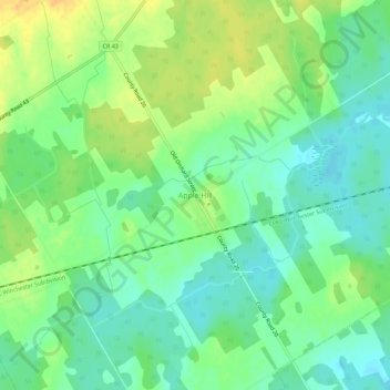
Carte topographique Apple Hill
Carte interactive
Cliquez sur la carte pour afficher l’altitude.
À propos de cette carte
Nom : Carte topographique Apple Hill, altitude, relief.
Altitude moyenne : 90 m
Altitude minimum : 77 m
Altitude maximum : 108 m
Autres cartes topographiques
Cliquez sur une carte pour visualiser sa topographie, son altitude et son relief.
Dalkeith
Canada > Ontario > Stormont, Dundas and Glengarry Counties > North Glengarry
Dalkeith, North Glengarry, Stormont, Dundas and Glengarry Counties, Eastern Ontario, Ontario, Canada
Altitude moyenne : 70 m
Dunvegan
Canada > Ontario > Stormont, Dundas and Glengarry Counties > North Glengarry
Dunvegan, North Glengarry, Stormont, Dundas and Glengarry Counties, Eastern Ontario, Ontario, Canada
Altitude moyenne : 87 m
Maxville
Canada > Ontario > Stormont, Dundas and Glengarry Counties > North Glengarry
Maxville, North Glengarry, Stormont, Dundas and Glengarry Counties, Eastern Ontario, Ontario, K0C 1T0, Canada
Altitude moyenne : 100 m
Alexandria
Canada > Ontario > Stormont, Dundas and Glengarry Counties > North Glengarry
Alexandria, North Glengarry, Stormont, Dundas and Glengarry Counties, Eastern Ontario, Ontario, K0C 1A0, Canada
Altitude moyenne : 84 m