
Faire un don
Équipez-vous pour votre prochaine aventure :
En tant que Partenaire Amazon, ce site perçoit une commission sur les achats éligibles sans surcoût pour vous.
Carte topographique Periyar River
Cliquez sur la carte pour afficher l’altitude.
Faire un don
Équipez-vous pour votre prochaine aventure :
En tant que Partenaire Amazon, ce site perçoit une commission sur les achats éligibles sans surcoût pour vous.
Periyar River
The southernmost part of the Cardamom Hills i.e. the source of Periyar River is a narrow valley extending south of Kumily. This is the southern extreme of the Periyar basin. It is less than 20 kilometres (12 mi) wide and is about 40 kilometres (25 mi) long. The upper catchments of Periyar extend as a wedge deep into the northeastern corner of the neighboring Pandalam Hills. This section of the Cardamom Hills extends deep into but is clearly separated from the Pandalam Hills. The main Western Ghats watershed line forming the eastern border of the Cardamom Hills is highest to the southeast of the Kumily Gap. Here the High Wavies branch off towards north-west into Tamil Nadu, with some peaks reaching elevations of over 1,900 metres (6,200 ft) along the border between Kerala and Tamil Nadu. Further south, the ridge along the watershed line is heavily forested. This part of the Cardamom Hills is called the Sivagiri Range and it extends south up to Chokkampatti Mala which is at the junction of Pamba and Periyar River basins. The southern boundary of the Cardamom Hills runs along a westerly spur hill starting from the Chokkampatti Mala which initially runs north and then turns northwest almost parallel to the Sivagiri Range. This ridge separates the basin of Pamba from Periyar. From its source near Chokkampatti Mala initially Periyar flows north between these two heavily forested ridges. The valley floor is at an elevation of 1,000 metres (3,300 ft) and the ridges on either side often reach 1,800 metres (5,900 ft). This valley of Periyar at its source and the valley of Kunthi River in the Silent Valley are the only two forested higher valleys in the Western Ghats left intact even now. The 925-square-kilometre (357 sq mi) Periyar Tiger Reserve is mostly within this southernmost part of the Cardamom Hills.
Faire un don
Équipez-vous pour votre prochaine aventure :
En tant que Partenaire Amazon, ce site perçoit une commission sur les achats éligibles sans surcoût pour vous.
À propos de cette carte
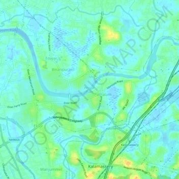
Nom : Carte topographique Periyar River, altitude, relief.
Altitude moyenne : 8 m
Altitude minimum : -4 m
Altitude maximum : 29 m
Faire un don
Équipez-vous pour votre prochaine aventure :
En tant que Partenaire Amazon, ce site perçoit une commission sur les achats éligibles sans surcoût pour vous.
Autres cartes topographiques
Cliquez sur une carte pour visualiser sa topographie, son altitude et son relief.