
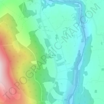
Carte topographique Ballyogan
Carte interactive
Cliquez sur la carte pour afficher l’altitude.
À propos de cette carte
Nom : Carte topographique Ballyogan, altitude, relief.
Altitude moyenne : 130 m
Altitude minimum : 2 m
Altitude maximum : 462 m
Autres cartes topographiques
Cliquez sur une carte pour visualiser sa topographie, son altitude et son relief.
The Rower
The Rower, The Municipal District of Callan — Thomastown, County Kilkenny, Leinster, Ireland
Altitude moyenne : 95 m
Killeens
Killeens, Coolhill, The Municipal District of Callan — Thomastown, County Kilkenny, Leinster, Ireland
Altitude moyenne : 63 m
Coon
Coon, The Municipal District of Castlecomer, County Kilkenny, Leinster, Ireland
Altitude moyenne : 221 m
Miltown
Miltown, Dunkitt, The Municipal District of Piltown, County Kilkenny, Leinster, Ireland
Altitude moyenne : 26 m
Freshford
Freshford, The Municipal District of Castlecomer, County Kilkenny, Leinster, Ireland
Altitude moyenne : 81 m
Aughatubbrid or Chatsworth
Aughatubbrid or Chatsworth, Clogh, The Municipal District of Castlecomer, County Kilkenny, Leinster, Ireland
Altitude moyenne : 196 m
Clonard
Clonard, Ballycallan, The Municipal District of Castlecomer, County Kilkenny, Leinster, Ireland
Altitude moyenne : 104 m
Kilkenny
Kilkenny, County Kilkenny, Leinster, Ireland
Altitude moyenne : 62 m
Mullinavat
Mullinavat, Killahy, The Municipal District of Piltown, County Kilkenny, Leinster, Ireland
Altitude moyenne : 90 m
Clogh
Clogh, The Municipal District of Castlecomer, County Kilkenny, Leinster, Ireland
Altitude moyenne : 145 m
Knocktopher
Knocktopher, The Municipal District of Callan — Thomastown, County Kilkenny, Leinster, Ireland
Altitude moyenne : 78 m
Kilree
Kilree, Kells, The Municipal District of Callan — Thomastown, County Kilkenny, Leinster, Ireland
Altitude moyenne : 71 m
Thomastown
Thomastown, The Municipal District of Callan — Thomastown, County Kilkenny, Leinster, Ireland
Altitude moyenne : 69 m
The Municipal District of Castlecomer
The Municipal District of Castlecomer, County Kilkenny, Leinster, Ireland
Altitude moyenne : 139 m
The Municipal District of Callan — Thomastown
The Municipal District of Callan — Thomastown, County Kilkenny, Leinster, Ireland
Altitude moyenne : 100 m
Priory
Priory, Kells, The Municipal District of Callan — Thomastown, County Kilkenny, Leinster, R95 EFR9, Ireland
Altitude moyenne : 63 m
Griffinstown
Griffinstown, Ullard, The Municipal District of Callan — Thomastown, County Kilkenny, Leinster, Ireland
Altitude moyenne : 95 m
Kilmacow
Ireland > County Kilkenny > Kilmacow
Kilmacow, The Municipal District of Piltown, County Kilkenny, Leinster, Ireland
Altitude moyenne : 28 m
Mooncoin
Ireland > County Kilkenny > Mooncoin
Mooncoin, The Municipal District of Piltown, County Kilkenny, Leinster, Ireland
Altitude moyenne : 31 m
The Municipal District of Piltown
The Municipal District of Piltown, County Kilkenny, Leinster, Ireland
Altitude moyenne : 89 m
Rathcoole
Rathcoole, The Municipal District of Castlecomer, County Kilkenny, Leinster, R95 YE10, Ireland
Altitude moyenne : 183 m
The Municipal District of Kilkenny City
The Municipal District of Kilkenny City, County Kilkenny, Leinster, Ireland
Altitude moyenne : 84 m
Dunnamaggan East
Dunnamaggan East, Dunnamaggan, The Municipal District of Callan — Thomastown, County Kilkenny, Leinster, Ireland
Altitude moyenne : 66 m
Freshford
Freshford, The Municipal District of Castlecomer, County Kilkenny, Leinster, Ireland
Altitude moyenne : 128 m
Kildrummy
Kildrummy, Kilmaganny, The Municipal District of Callan — Thomastown, County Kilkenny, Leinster, Ireland
Altitude moyenne : 121 m