
Carte topographique Cotmanhay
Carte interactive
Cliquez sur la carte pour afficher l’altitude.
À propos de cette carte
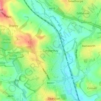
Nom : Carte topographique Cotmanhay, altitude, relief.
Altitude moyenne : 71 m
Altitude minimum : 44 m
Altitude maximum : 123 m
Autres cartes topographiques
Cliquez sur une carte pour visualiser sa topographie, son altitude et son relief.
West Hallam
United Kingdom > England > Derbyshire > Borough of Erewash
West Hallam, Borough of Erewash, Derbyshire, England, DE7 6PD, United Kingdom
Altitude moyenne : 91 m