
Carte topographique Watertown
Carte interactive
Cliquez sur la carte pour afficher l’altitude.
À propos de cette carte
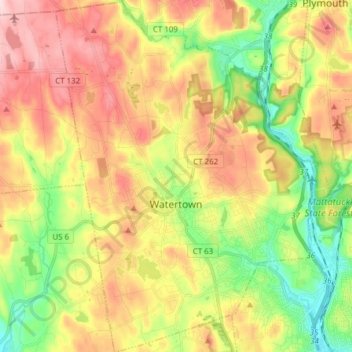
Nom : Carte topographique Watertown, altitude, relief.
Lieu : Watertown, Litchfield County, Connecticut, United States (41.55783 -73.17076 41.67272 -73.05736)
Altitude moyenne : 199 m
Altitude minimum : 75 m
Altitude maximum : 336 m
Watertown is in southeastern Litchfield County and is bordered to the southeast by the city of Waterbury in New Haven County. Other bordering towns are Middlebury to the south, Woodbury and Bethlehem to the west, Morris to the northwest, and Thomaston to the east. It is in the Eastern Standard time zone. The elevation at the town center is 583 feet (178 m).
Autres cartes topographiques
Cliquez sur une carte pour visualiser sa topographie, son altitude et son relief.
Plymouth
United States > Connecticut > Litchfield County > Plymouth
Plymouth, Litchfield County, Connecticut, United States
Altitude moyenne : 214 m
Winchester
United States > Connecticut > Litchfield County
Winchester, Litchfield County, Connecticut, United States
Altitude moyenne : 335 m
West Cornwall
United States > Connecticut > Litchfield County > Cornwall > West Cornwall
West Cornwall, Cornwall, Litchfield County, Connecticut, 06796, United States
Altitude moyenne : 288 m
East Canaan
United States > Connecticut > Litchfield County > North Canaan > East Canaan
East Canaan, North Canaan, Litchfield County, Connecticut, 06024, United States
Altitude moyenne : 284 m
Hickory Haven
United States > Connecticut > Litchfield County > New Milford > Hickory Haven
Hickory Haven, New Milford, Litchfield County, Connecticut, 06776, United States
Altitude moyenne : 185 m
Bantam Lake
United States > Connecticut > Litchfield County > Morris
Bantam Lake, Morris, Litchfield County, Connecticut, United States
Altitude moyenne : 282 m
Macedonia
United States > Connecticut > Litchfield County > Kent > Macedonia
Macedonia, Kent, Litchfield County, Connecticut, 06757, United States
Altitude moyenne : 250 m
Bridgewater
United States > Connecticut > Litchfield County > Bridgewater
Bridgewater, Litchfield County, Connecticut, 06752, United States
Altitude moyenne : 139 m
Bantam
United States > Connecticut > Litchfield County > Litchfield
Bantam, Litchfield, Litchfield County, Connecticut, United States
Altitude moyenne : 275 m
Canaan
United States > Connecticut > Litchfield County > Canaan
Canaan, Litchfield County, Connecticut, 06031, United States
Altitude moyenne : 334 m
Northville
United States > Connecticut > Litchfield County > New Milford > Northville
Northville, New Milford, Litchfield County, Connecticut, United States
Altitude moyenne : 191 m
Canaan Valley
United States > Connecticut > Litchfield County > North Canaan > Canaan Valley
Canaan Valley, North Canaan, Litchfield County, Connecticut, 06024, United States
Altitude moyenne : 293 m
Park Lane
United States > Connecticut > Litchfield County > New Milford > Park Lane
Park Lane, New Milford, Litchfield County, Connecticut, 06776, United States
Altitude moyenne : 136 m
Barkhamsted
United States > Connecticut > Litchfield County
Barkhamsted, Litchfield County, Connecticut, United States
Altitude moyenne : 238 m
Bear Mountain
United States > Connecticut > Litchfield County > Salisbury
Bear Mountain, Salisbury, Litchfield County, Connecticut, United States
Altitude moyenne : 544 m