
Carte topographique Bally
Carte interactive
Cliquez sur la carte pour afficher l’altitude.
À propos de cette carte
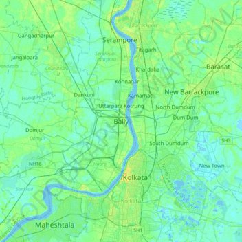
Nom : Carte topographique Bally, altitude, relief.
Altitude moyenne : 6 m
Altitude minimum : -3 m
Altitude maximum : 23 m
Bally is located at 22°39′N 88°20′E / 22.65°N 88.34°E / 22.65; 88.34 and also the northern-most part of Howrah city. It has an average elevation of 15 metres (49 feet). Bally is separated from Uttarpara, Hooghly by Bally Canal (Bally Khal) at its north. A Bridge was constructed over Bally Canal in 1846 to join the two localities.