
Carte topographique Cape York
Carte interactive
Cliquez sur la carte pour afficher l’altitude.
À propos de cette carte
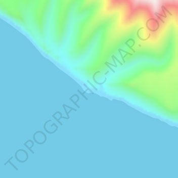
Nom : Carte topographique Cape York, altitude, relief.
Lieu : Cape York, Nome, Alaska, United States of America (65.41445 -167.46464 65.41455 -167.46454)
Altitude moyenne : 75 m
Altitude minimum : 0 m
Altitude maximum : 556 m
Autres cartes topographiques
Cliquez sur une carte pour visualiser sa topographie, son altitude et son relief.
Noatak
United States of America > Alaska > Noatak
Noatak, Northwest Arctic, Alaska, United States of America
Altitude moyenne : 23 m
Johns
United States of America > Alaska
Johns, Unorganized Borough, Alaska, United States of America
Altitude moyenne : 823 m
Mount Pendleton
United States of America > Alaska
Mount Pendleton, Denali, Alaska, United States of America
Altitude moyenne : 1’978 m
Aleutians East
United States of America > Alaska
Aleutians East, Alaska, United States of America
Altitude moyenne : 23 m
North Slope
United States of America > Alaska
North Slope, Alaska, United States of America
Altitude moyenne : 214 m
Northwest Arctic
United States of America > Alaska
Northwest Arctic, Alaska, United States of America
Altitude moyenne : 296 m
Denali National Park and Preserve
United States of America > Alaska
Denali National Park and Preserve, Alaska, United States of America
Altitude moyenne : 777 m