
Carte topographique Qanateghestan
Carte interactive
Cliquez sur la carte pour afficher l’altitude.
À propos de cette carte
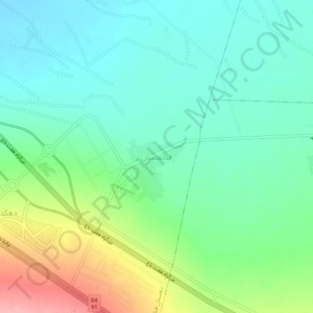
Nom : Carte topographique Qanateghestan, altitude, relief.
Lieu : Qanateghestan, بخش ماهان, Kerman County, Kerman Province, Iran (30.05810 57.21315 30.09810 57.25315)
Altitude moyenne : 1’857 m
Altitude minimum : 1’821 m
Altitude maximum : 1’941 m
Autres cartes topographiques
Cliquez sur une carte pour visualiser sa topographie, son altitude et son relief.
حوض نخعی
Iran > Kerman Province > Kerman County > Kerman
حوض نخعی, فارابی, Sarjangaldari Suburb, منطقه ۲, Kerman, بخش مرکزی شهرستان کرمان, Kerman County, Kerman Province, Iran
Altitude moyenne : 1’758 m
lut lake
Iran > Kerman Province > Kerman County > دهستان تکاب
lut lake, دهستان تکاب, بخش شهداد, Kerman County, Kerman Province, Iran
Altitude moyenne : 262 m
Shahdad
Iran > Kerman Province > Kerman County > Shahdad
Shahdad, بخش شهداد, Kerman County, Kerman Province, Iran
Altitude moyenne : 452 m
دهستان اندوهجرد
Iran > Kerman Province > Kerman County
دهستان اندوهجرد, بخش شهداد, Kerman County, Kerman Province, Iran
Altitude moyenne : 565 m
دهستان تکاب
Iran > Kerman Province > Kerman County
دهستان تکاب, بخش شهداد, Kerman County, Kerman Province, Iran
Altitude moyenne : 637 m
Mahan
Iran > Kerman Province > Kerman County
Mahan, بخش ماهان, Kerman County, Kerman Province, Iran
Altitude moyenne : 1’944 m
Lut Desert
Iran > Kerman Province > Kerman County > دهستان تکاب
Lut Desert, دهستان تکاب, بخش شهداد, Kerman County, Kerman Province, Iran
Altitude moyenne : 709 m
Langar
Iran > Kerman Province > Kerman County > Mahan
Langar, Mahan, بخش ماهان, Kerman County, Kerman Province, Iran
Altitude moyenne : 1’863 m