

Carte topographique Angaston
Cliquez sur la carte pour afficher l’altitude.
Angaston
Angaston is a town on the eastern side of the Barossa Valley in South Australia, 77 km northeast of Adelaide. Its elevation is 347 m, one of the highest points in the valley, and has an average rainfall of 561 mm. Angaston was originally known as German Pass, but was later renamed after the politician, banker and pastoralist George Fife Angas, who settled in the area in the 1850s. Angaston is in the Barossa Council local government area, the state electoral district of Schubert and the federal Division of Barker.
À propos de cette carte
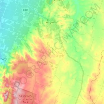
Nom : Carte topographique Angaston, altitude, relief.
Lieu : Angaston, South Australia, Australia (-34.58371 139.00038 -34.48536 139.13416)
Altitude moyenne : 397 m
Altitude minimum : 262 m
Altitude maximum : 597 m
Autres cartes topographiques
Cliquez sur une carte pour visualiser sa topographie, son altitude et son relief.
Adelaide
Australia > South Australia > Adelaide
Adelaide is north of the Fleurieu Peninsula, on the Adelaide Plains between the Gulf St Vincent and the low-lying Mount Lofty Ranges. The city stretches 20 km (12 mi) from the coast to the foothills, and 90 km (56 mi) from Gawler at its northern extent to Sellicks Beach in the south. According to the Regional…
Altitude moyenne : 148 m










Port Neill
Matthew Flinders sailed past on 7 March 1802 and reported 'low front land, somewhat sandy, with raised land inland and of a barren appearance, its elevation diminishing to the northward.' The first land-based European exploration took place in April 1840, when the party of Governor Gawler, John Hill, and…
Altitude moyenne : 9 m




Dullingari
Australia > South Australia > Pastoral Unincorporated Area > Innamincka
Altitude moyenne : 89 m


Port Noarlunga Reef Sanctuary Zone
Australia > South Australia > City of Onkaparinga > Adelaide
Altitude moyenne : 1 m


Kalumunda Forest Reserve
Australia > South Australia > The District Council of Yankalilla
Altitude moyenne : 265 m

Shallow Lagoon
Australia > South Australia > Yorke Peninsula Council > Minlaton
Altitude moyenne : 77 m


Musgrave Ranges
Australia > South Australia > Anangu Pitjantjatjara Yankunytjatjara
Altitude moyenne : 1’054 m

Mount Compass
Australia > South Australia > Alexandrina Council > Mount Compass
Altitude moyenne : 275 m



Happy Valley Reservior
Australia > South Australia > City of Onkaparinga > Adelaide
Altitude moyenne : 173 m


Victoria Square
Australia > South Australia > Adelaide City Council > Adelaide
Altitude moyenne : 47 m


Bookabourdie Waterhole
Australia > South Australia > Pastoral Unincorporated Area > Innamincka
Altitude moyenne : 44 m

Stokes Hill Lookout
Australia > South Australia > Pastoral Unincorporated Area
Altitude moyenne : 684 m


Nullabor Plain
Australia > South Australia > Pastoral Unincorporated Area
One theory is that the whole area was uplifted by crustal movements in the Miocene, and since then, erosion by wind and rain has reduced its thickness. The plain has most likely never had any major defining topographic features, resulting in the extremely flat terrain across the plain today.
Altitude moyenne : 117 m


Kingston On Murray
Australia > South Australia > The District Council of Loxton Waikerie > Kingston On Murray
Altitude moyenne : 29 m


Campbelltown Re-Vegitation Community Reserve
Australia > South Australia > Adelaide
Altitude moyenne : 91 m
Cape Willoughby Conservation Park
Australia > South Australia > Kangaroo Island Council
Altitude moyenne : 12 m

Mungerannie
Australia > South Australia > Pastoral Unincorporated Area > Mungerannie
Altitude moyenne : 59 m

Olympic Dam
Australia > South Australia > Municipal Council of Roxby Downs > Olympic Dam
Altitude moyenne : 104 m


Leigh Creek
Australia > South Australia > Pastoral Unincorporated Area > Leigh Creek
Altitude moyenne : 267 m


Streaky Bay
Australia > South Australia > The District Council of Streaky Bay > Streaky Bay
Altitude moyenne : 22 m

Fowlers Bay
Australia > South Australia > Pastoral Unincorporated Area > Fowlers Bay
Altitude moyenne : 3 m


