
Carte topographique Tomintoul
Cliquez sur la carte pour afficher l’altitude.
Tomintoul
Tomintoul has an oceanic climate (Cfb), bordering on subpolar oceanic (Cfc). Since March 2025, Tomintoul has an official MetOffice weather station. Manual readings are sent to the Met-Office on a daily basis. The temperature values below are simulated and not taken from this weather station. Due to the villages' location northeast of the Cairngorms massif, it is exposed to many snow-bearing wind directions; this is consolidated by its elevation of 345m above sea level and its latitude at 57°N. As a result, Tomintoul is one of the coldest and snowiest settlements in the UK. The minimum temperature of −12.6 °C (9.3 °F) was registered on 21 November 2025 in Tomintoul.
À propos de cette carte
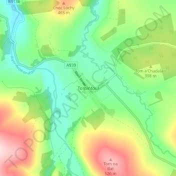
Nom : Carte topographique Tomintoul, altitude, relief.
Lieu : Tomintoul, Moray, Scotland, AB37 9ET, United Kingdom (57.23193 -3.39932 57.27193 -3.35932)
Altitude moyenne : 374 m
Altitude minimum : 274 m
Altitude maximum : 546 m
Autres cartes topographiques
Cliquez sur une carte pour visualiser sa topographie, son altitude et son relief.
Fochabers
United Kingdom > Scotland > Moray
The present village owes its existence to Alexander Gordon, 4th Duke of Gordon (1743–1827). During the late eighteenth century, during the Scottish Enlightenment, it was fashionable for landowners to found new towns and villages; these can be recognised all over Scotland, because unlike their predecessors…
Altitude moyenne : 59 m