
Faire un don
Équipez-vous pour votre prochaine aventure :
En tant que Partenaire Amazon, ce site perçoit une commission sur les achats éligibles sans surcoût pour vous.
Carte topographique Tauplitz
Cliquez sur la carte pour afficher l’altitude.
Faire un don
Équipez-vous pour votre prochaine aventure :
En tant que Partenaire Amazon, ce site perçoit une commission sur les achats éligibles sans surcoût pour vous.
À propos de cette carte
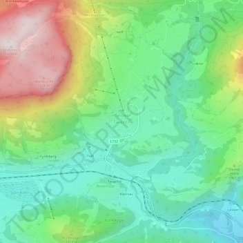
Nom : Carte topographique Tauplitz, altitude, relief.
Altitude moyenne : 1’010 m
Altitude minimum : 731 m
Altitude maximum : 1’559 m
Faire un don
Équipez-vous pour votre prochaine aventure :
En tant que Partenaire Amazon, ce site perçoit une commission sur les achats éligibles sans surcoût pour vous.
Autres cartes topographiques
Cliquez sur une carte pour visualiser sa topographie, son altitude et son relief.
Faire un don
Équipez-vous pour votre prochaine aventure :
En tant que Partenaire Amazon, ce site perçoit une commission sur les achats éligibles sans surcoût pour vous.
Grundlsee
Austria > Styria > Bezirk Liezen
The climate in Grundlsee is determined by its geographical location in the Aussee Basin. It is characterized mainly by the high altitude and the location in the northern congestion area. The result is, in the case of flow conditions from the west to the north, often days of precipitation, which in winter are…
Altitude moyenne : 1’240 m
Ramsau am Dachstein
Austria > Styria > Bezirk Liezen
Ramsau am Dachstein is situated between the Dachstein range of mountains in the north and the Enns valley in the south. While the Dachstein range contains peaks up to 2,995 m (9,826 ft) and the towns of the Enns valley, such as Schladming, lie at around 700 m (2,300 ft) above sea level, the Ramsau plateau is a…
Altitude moyenne : 1’526 m
Faire un don
Équipez-vous pour votre prochaine aventure :
En tant que Partenaire Amazon, ce site perçoit une commission sur les achats éligibles sans surcoût pour vous.
Faire un don
Équipez-vous pour votre prochaine aventure :
En tant que Partenaire Amazon, ce site perçoit une commission sur les achats éligibles sans surcoût pour vous.