
Carte topographique American River
Carte interactive
Cliquez sur la carte pour afficher l’altitude.
À propos de cette carte
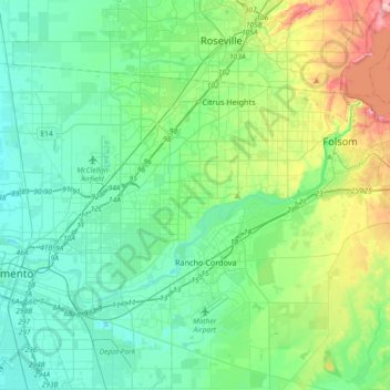
Nom : Carte topographique American River, altitude, relief.
Altitude moyenne : 44 m
Altitude minimum : 0 m
Altitude maximum : 197 m
The North Fork is the longest tributary of the American River, at 88 miles (142 km). It begins at an elevation of about 7,900 feet (2,400 m) near Lake Tahoe in Placer County at Mountain Meadow Lake, just northeast of Granite Chief and immediately due west of Palisades Tahoe (formerly Squaw Valley) Ski Resort. It flows westward through remote wilderness areas.
Autres cartes topographiques
Cliquez sur une carte pour visualiser sa topographie, son altitude et son relief.
Soudan
United States > California > Sacramento County > Rancho Cordova
Soudan, Rancho Cordova, Sacramento County, CAL Fire Northern Region, California, 95670, United States
Altitude moyenne : 35 m