
Carte topographique McDonough Canal
Carte interactive
Cliquez sur la carte pour afficher l’altitude.
À propos de cette carte
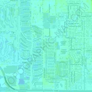
Nom : Carte topographique McDonough Canal, altitude, relief.
Altitude moyenne : 3 m
Altitude minimum : -1 m
Altitude maximum : 7 m
Autres cartes topographiques
Cliquez sur une carte pour visualiser sa topographie, son altitude et son relief.
Cape Coral
United States > Florida > Lee County > Cape Coral
Cape Coral, Lee County, Florida, 33914-4648, United States
Altitude moyenne : 3 m
Calusa Land Trust and Nature Preserve of Pine Island
United States > Florida > Lee County > Cape Coral
Calusa Land Trust and Nature Preserve of Pine Island, Cape Coral, Lee County, Florida, United States
Altitude moyenne : 1 m
Coral Lakes
United States > Florida > Lee County > Cape Coral
Coral Lakes, Cape Coral, Lee County, Florida, 33909, United States
Altitude moyenne : 6 m
Sacremento Canal
United States > Florida > Lee County > Cape Coral
Sacremento Canal, Cape Coral, Lee County, Florida, 33904, United States
Altitude moyenne : 4 m