
Carte topographique Kathmandu
Carte interactive
Cliquez sur la carte pour afficher l’altitude.
À propos de cette carte
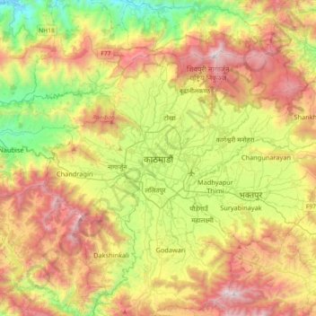
Nom : Carte topographique Kathmandu, altitude, relief.
Altitude moyenne : 1’538 m
Altitude minimum : 606 m
Altitude maximum : 2’733 m
Kathmandu, officially Kathmandu Metropolitan City, is the capital and most populous city of Nepal with 845,767 inhabitants living in 105,649 households in 2021 and 2.9 million people in its urban agglomeration. It is located in the Kathmandu Valley, a large valley in the high plateaus in central Nepal, at an altitude of 1,400 metres (4,600 feet).
Autres cartes topographiques
Cliquez sur une carte pour visualiser sa topographie, son altitude et son relief.
Budhanilkantha
Nepal > Bagmati Province > Kathmandu
Budhanilkantha, Budhanilkantha Municipality, Kathmandu, Bagmati Province, 22644, Nepal
Altitude moyenne : 1’665 m
Budhanilkantha Municipality
Nepal > Bagmati Province > Kathmandu
Budhanilkantha Municipality, Kathmandu, Bagmati Province, Nepal
Altitude moyenne : 1’589 m
Shankharapur
Nepal > Bagmati Province > Kathmandu
Shankharapur, Kathmandu, Bagmati Province, Nepal
Altitude moyenne : 1’520 m
Tokha
Nepal > Bagmati Province > Kathmandu
Tokha, Tokha Municipality, Kathmandu, Bagmati Province, 44607, Nepal
Altitude moyenne : 1’366 m