
Carte topographique Bonners Ferry
Carte interactive
Cliquez sur la carte pour afficher l’altitude.
À propos de cette carte
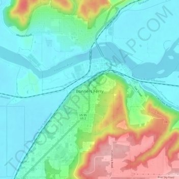
Nom : Carte topographique Bonners Ferry, altitude, relief.
Altitude moyenne : 584 m
Altitude minimum : 531 m
Altitude maximum : 716 m
Bonners Ferry is located 27 miles (43.5 km) south of the Canada-United States border at 48°41′32″N 116°19′3″W / 48.69222°N 116.31750°W / 48.69222; -116.31750 (48.692110, −116.317626), at an altitude of 1,896 feet (578 m). According to the United States Census Bureau, the city has a total area of 2.61 square miles (6.76 km2), of which 2.44 square miles (6.32 km2) is land and 0.17 square miles (0.44 km2) is water.
Autres cartes topographiques
Cliquez sur une carte pour visualiser sa topographie, son altitude et son relief.
Canida Peak
United States > Idaho > Boundary County
Canida Peak, Boundary County, Idaho, United States
Altitude moyenne : 1’345 m