
Carte topographique Crimean Peninsula
Carte interactive
Cliquez sur la carte pour afficher l’altitude.
À propos de cette carte
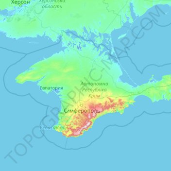
Nom : Carte topographique Crimean Peninsula, altitude, relief.
Altitude moyenne : 35 m
Altitude minimum : -5 m
Altitude maximum : 1’514 m
The main range of these mountains rises with extraordinary abruptness from the deep floor of the Black Sea to an altitude of 600–1,545 metres (1,969–5,069 ft), beginning at the southwest point of the peninsula, called Cape Fiolent. Some Greek myths state that this cape was supposedly crowned with the temple of Artemis where Iphigeneia officiated as priestess. Uchan-su, on the south slope of the mountains, is the highest waterfall in Crimea.
Autres cartes topographiques
Cliquez sur une carte pour visualiser sa topographie, son altitude et son relief.
Sevastopol
Sevastopol, Southern Federal District, 99001, Russia
Altitude moyenne : 58 m