
Carte topographique Crownthorpe
Carte interactive
Cliquez sur la carte pour afficher l’altitude.
À propos de cette carte
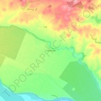
Nom : Carte topographique Crownthorpe, altitude, relief.
Lieu : Crownthorpe, Hastings District, Hawke's Bay, New Zealand (-39.59106 176.54182 -39.55106 176.58182)
Altitude moyenne : 168 m
Altitude minimum : 102 m
Altitude maximum : 239 m
Autres cartes topographiques
Cliquez sur une carte pour visualiser sa topographie, son altitude et son relief.
Hastings
New Zealand > Hawke's Bay > Hastings District
Hastings, Hastings District, Hawke's Bay, 4122, New Zealand
Altitude moyenne : 68 m
Te Haroto
New Zealand > Hawke's Bay > Hastings District
Te Haroto, Hastings District, Hawke's Bay, New Zealand
Altitude moyenne : 647 m
Kereru
New Zealand > Hawke's Bay > Hastings District
Kereru, Hastings District, Hawke's Bay, New Zealand
Altitude moyenne : 305 m
Havelock North
New Zealand > Hawke's Bay > Hastings District
Havelock North, Hastings District, Hawke's Bay, 4130, New Zealand
Altitude moyenne : 45 m
Poukawa
New Zealand > Hawke's Bay > Hastings District
Poukawa, Hastings District, Hawke's Bay, New Zealand
Altitude moyenne : 49 m
Twyford
New Zealand > Hawke's Bay > Hastings District > Hastings
Twyford, Hastings, Hastings District, Hawke's Bay, 4154, New Zealand
Altitude moyenne : 19 m
Waikoau
New Zealand > Hawke's Bay > Hastings District
Waikoau, Hastings District, Hawke's Bay, New Zealand
Altitude moyenne : 290 m
Tutira
New Zealand > Hawke's Bay > Hastings District
Tutira, Hastings District, Hawke's Bay, New Zealand
Altitude moyenne : 191 m
Mangateretere
New Zealand > Hawke's Bay > Hastings District > Hastings
Mangateretere, Hastings, Hastings District, Hawke's Bay, 4172, New Zealand
Altitude moyenne : 9 m
Maraekakaho
New Zealand > Hawke's Bay > Hastings District > Maraekakaho
Maraekakaho, Hastings District, Hawke's Bay, New Zealand
Altitude moyenne : 118 m
Matangi
New Zealand > Hawke's Bay > Hastings District > Hastings
Matangi, Hastings, Hastings District, Hawke's Bay, 4295, New Zealand
Altitude moyenne : 187 m
Otatara Pā
New Zealand > Hawke's Bay > Hastings District > Napier > Waiohiki
Otatara Pā, Springfield Road, Waiohiki, Napier, Hastings District, Hawke's Bay, 4142, New Zealand
Altitude moyenne : 31 m
Sherenden
New Zealand > Hawke's Bay > Hastings District > Sherenden
Sherenden, Hastings District, Hawke's Bay, New Zealand
Altitude moyenne : 258 m
Lake Tutira
New Zealand > Hawke's Bay > Hastings District
Lake Tutira, Hastings District, Hawke's Bay, New Zealand
Altitude moyenne : 197 m
Maraetotara River
New Zealand > Hawke's Bay > Hastings District
Maraetotara River, Hastings District, Hawke's Bay, 4180, New Zealand
Altitude moyenne : 105 m