
Carte topographique Hakuba
Carte interactive
Cliquez sur la carte pour afficher l’altitude.
À propos de cette carte
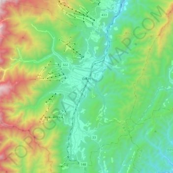
Nom : Carte topographique Hakuba, altitude, relief.
Lieu : Hakuba, Kita-Azumi County, Nagano Prefecture, Japan (36.61393 137.75002 36.76769 137.94154)
Altitude moyenne : 1’120 m
Altitude minimum : 528 m
Altitude maximum : 2’578 m
The village has humid continental climate (Köppen Dfa), with cold, extremely snowy winters, and warm, rainy summers. With temperatures cooled by the elevation, monthly 24-hour average temperature ranges from −2.8 °C (27.0 °F) in January to 22.6 °C (72.7 °F) in July. Hakuba receives approximately 11 meters of snowfall annually, with most snowfall occurring in the months of January and February.
Autres cartes topographiques
Cliquez sur une carte pour visualiser sa topographie, son altitude et son relief.
Mount Shirouma
Japan > Kita-Azumi County > Hakuba
Mount Shirouma, Hakuba, Kita-Azumi County, Nagano Prefecture, Japan
Altitude moyenne : 2’461 m