
Carte topographique Dunsfold
Cliquez sur la carte pour afficher l’altitude.
Dunsfold
St Mary & All Saints' Church is a Norman building, containing the oldest pews in England. The nearby Holy Well was a site of pilgrimage – its waters were thought to cure diseases of the eye. It would be consistent with the topography of the site that the well be a pre-Christian site and the church itself be constructed on a man-made hill of pre-Christian origin.
À propos de cette carte
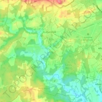
Nom : Carte topographique Dunsfold, altitude, relief.
Lieu : Dunsfold, Waverley, Surrey, England, United Kingdom (51.07968 -0.59778 51.13305 -0.53668)
Altitude moyenne : 52 m
Altitude minimum : 22 m
Altitude maximum : 97 m
Autres cartes topographiques
Cliquez sur une carte pour visualiser sa topographie, son altitude et son relief.
Hankley Common
United Kingdom > England > Surrey > Waverley > Thursley > Truxford
Altitude moyenne : 70 m
Camelsdale
United Kingdom > England > Surrey > Waverley > Haslemere > Shottermill
Altitude moyenne : 166 m
Floodplain (seasonal)
United Kingdom > England > Surrey > Waverley > Farnham > Wrecclesham
Altitude moyenne : 94 m