Géolocaliser

Carte topographique Baltray

Cliquez sur la carte pour afficher l’altitude.

À propos de cette carte

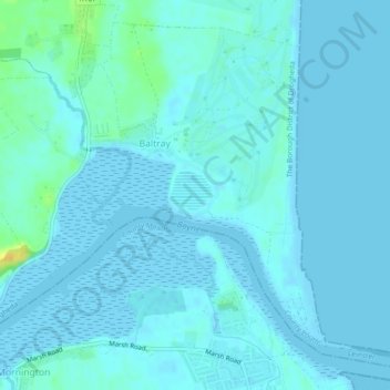
Nom : Carte topographique Baltray, altitude, relief.

Lieu : Baltray, Termonfeckin, The Borough District of Drogheda, County Louth, Leinster, Ireland (53.72167 -6.27603 53.74561 -6.23877)

Altitude moyenne : 3 m

Altitude minimum : -2 m

Altitude maximum : 25 m

Autres cartes topographiques

Cliquez sur une carte pour visualiser sa topographie, son altitude et son relief.

Cork

Ireland > County Cork > Cork

Altitude moyenne : 94 m

Galway City

Ireland > Galway City

Altitude moyenne : 26 m

Cromane

Ireland

Altitude moyenne : 3 m

Maghera Strand

Ireland

Altitude moyenne : 37 m

Bray

Ireland > County Wicklow > Bray

Altitude moyenne : 58 m

Killarney

Ireland > County Kerry > Killarney

Altitude moyenne : 66 m

River Shannon

Ireland

Altitude moyenne : 39 m

Malin Head

Ireland > County Donegal

Altitude moyenne : 4 m

Glencullen

Ireland > County Dublin

Altitude moyenne : 285 m

Kilkee Cliffs

Ireland

Altitude moyenne : 19 m

Clifden Bay

Ireland

Altitude moyenne : 41 m

Galway Bay

Ireland

Altitude moyenne : 0 m

Dollymount

Ireland

Altitude moyenne : 6 m

Bartlemy

Ireland > County Cork

Altitude moyenne : 98 m

Seefin

Ireland > County Waterford

Altitude moyenne : 498 m

Spike Island

Ireland > County Cork

Altitude moyenne : 2 m

Letterkenny

Ireland > County Donegal > Letterkenny

Altitude moyenne : 93 m

Tramore Valley Park

Ireland > County Cork > Cork

Altitude moyenne : 28 m

Blackrock

Ireland > County Louth

Altitude moyenne : 5 m

Galtymore

Ireland > County Limerick > The Municipal District of Cappamore — Kilmallock

Galtymore or Galteemore (Irish: Cnoc Mór na nGaibhlte, meaning 'big hill of the Galtees') is a mountain in the province of Munster, Ireland. At 917.9 metres (3,011 ft 6 in), it is one of Ireland's highest mountains, being the 12th-highest on the Arderin list, and 14th-highest on the Vandeleur-Lynam list.…

Altitude moyenne : 594 m

Lough Nagreany

Ireland > County Donegal > Letterkenny

Altitude moyenne : 36 m

Cornaseer

Ireland > County Cavan

Altitude moyenne : 113 m

Knockavilla

Ireland > County Cork

Altitude moyenne : 85 m

Moneystown

Ireland > County Wicklow

Altitude moyenne : 223 m

Ballybrown

Ireland > County Limerick > Limerick

Altitude moyenne : 9 m

Geevagh

Ireland > County Sligo

Altitude moyenne : 92 m

Annayalla

Ireland > County Monaghan

Altitude moyenne : 123 m

Doolin Cave

Ireland > County Clare

Altitude moyenne : 87 m

Inis Meáin

Ireland > County Donegal

Altitude moyenne : 1 m

Knockdrin

Ireland

Altitude moyenne : 96 m

Ballycurry

Ireland

Altitude moyenne : 178 m

Ballyedmond

Ireland

Altitude moyenne : 73 m

Furry Glen

Ireland

Altitude moyenne : 44 m

Trout Lake

Ireland

Altitude moyenne : 81 m

Tory Hill

Ireland

Altitude moyenne : 131 m

Mizen Head

Ireland > County Cork

Altitude moyenne : 25 m

Dowth

Ireland

Altitude moyenne : 32 m

Great Skellig

Ireland

Altitude moyenne : 1 m

Spinans Hill

Ireland

Altitude moyenne : 244 m

Gaulstown Castle

Ireland

Altitude moyenne : 181 m

Skeaghvasteen

Ireland

Altitude moyenne : 97 m

Tibberaghny Castle

Ireland

Altitude moyenne : 18 m

Myles Big Stone

Ireland

Altitude moyenne : 89 m

Dunlicky Point

Ireland

Altitude moyenne : 18 m

Doulus Head

Ireland

Altitude moyenne : 16 m

Bolus Head

Ireland

Altitude moyenne : 28 m

Galley Head

Ireland

Altitude moyenne : 3 m

Downeen Point

Ireland

Altitude moyenne : 11 m

Frower Point

Ireland

Altitude moyenne : 20 m

Knockadoon Head

Ireland

Altitude moyenne : 6 m

Mine Head

Ireland

Altitude moyenne : 22 m

Glendoo Mountain

Ireland

Altitude moyenne : 480 m

Crohy Head Sea Arch

Ireland

Altitude moyenne : 28 m

Dawros Bay

Ireland

Altitude moyenne : 6 m

Portacloy Bay

Ireland

Altitude moyenne : 57 m

Mace Head

Ireland

Altitude moyenne : 3 m

Doonbeg Head

Ireland

Altitude moyenne : 32 m

Lambs Head Bay

Ireland

Altitude moyenne : 14 m

Boyne

Ireland > County Meath

Altitude moyenne : 29 m

Donabate Beach

Ireland > County Dublin

Altitude moyenne : 2 m

Bohermeen

Ireland > County Meath

Altitude moyenne : 74 m

Killiney Hill

Ireland > County Dublin > Killiney

Altitude moyenne : 40 m

Nohoval

Ireland > County Cork

Altitude moyenne : 56 m

Sneem

Ireland > County Kerry > Scrahanagaur

Altitude moyenne : 27 m

Poolbeg Lighthouse

Ireland > County Dublin > Dublin

Altitude moyenne : 0 m

Ardclough

Ireland > County Kildare

Altitude moyenne : 76 m

Ballinagh

Ireland > County Cavan > Bellananagh

Altitude moyenne : 94 m

Blacklion

Ireland > County Cavan

Altitude moyenne : 92 m

Knockmore

Ireland > County Mayo

Altitude moyenne : 108 m

Knockaderry

Ireland > County Waterford > Coolnasmear

Altitude moyenne : 147 m

Beaumont Park

Ireland > County Cork > Cork

Altitude moyenne : 12 m

Stonyford

Ireland > County Kilkenny

Altitude moyenne : 64 m

Ward Cross

Ireland > County Dublin

Altitude moyenne : 75 m

Clare

Ireland > County Galway

Altitude moyenne : 30 m

Hugginstown

Ireland > County Kilkenny

Altitude moyenne : 129 m

Watergrasshill

Ireland > County Cork

According to A Topographical Dictionary of Ireland, published by Samuel Lewis in 1837, Watergrasshill then had a population of 533 people.

Altitude moyenne : 164 m

Mount Brandon

Ireland > County Kerry

Altitude moyenne : 572 m

Cashlaundrumlahan

Ireland > County Galway

Altitude moyenne : 310 m

Bettystown

Ireland > County Meath

Altitude moyenne : 6 m

Beenkeragh

Ireland > County Kerry

Beenkeragh is the second-highest peak in Ireland, on both the Arderin and Vandeleur-Lynam lists. It is the 179th-highest mountain in Britain and Ireland on the Simm classification. Beenkeragh is regarded by the Scottish Mountaineering Club ("SMC") as one of 34 Furths, which is a mountain above 3,000 ft (914 m)…

Altitude moyenne : 654 m

Caher

Ireland > County Kerry

Caher is the 200th–highest mountain in Britain and Ireland on the Simm classification. Caher is regarded by the Scottish Mountaineering Club ("SMC") as one of 34 Furths, which is a mountain above 3,000 ft (914.4 m) in elevation, and meets the other SMC criteria for a Munro (e.g. "sufficient separation"), but…

Altitude moyenne : 617 m

Knocknapeasta

Ireland > County Kerry

It is the 231st-highest mountain in Britain and Ireland on the Simm classification. Cnoc na Péiste is regarded by the Scottish Mountaineering Club ("SMC") as one of 34 Furths, which is a mountain above 3,000 ft (914.4 m) in elevation, and meets the other SMC criteria for a Munro (e.g. "sufficient…

Altitude moyenne : 579 m

Lugnaquilla

Ireland > County Wicklow

Lugnaquilla is the 432nd-highest and 21st most prominent mountain in Britain and Ireland, on the Simms classification. It is regarded by the Scottish Mountaineering Club (SMC) as one of 34 Furths, which is a mountain above 3,000 ft (914 m) in elevation, and meets the other SMC criteria for a Munro (e.g.…

Altitude moyenne : 696 m

Baurtregaum

Ireland > County Kerry

Altitude moyenne : 606 m

Caherconree

Ireland > County Kerry

Altitude moyenne : 536 m

Mweelrea

Ireland > County Mayo

Altitude moyenne : 422 m

Errigal

Ireland > County Donegal

Altitude moyenne : 295 m

Slieve League

Ireland > County Donegal

Altitude moyenne : 233 m

Devil's Bit Mountain

Ireland > County Tipperary

Altitude moyenne : 291 m

Slieve Foye

Ireland > County Louth

Altitude moyenne : 287 m

Blackstairs Mountain

Ireland > County Carlow

Altitude moyenne : 429 m

River Lee (North Channel)

Ireland > County Cork > Cork

Altitude moyenne : 49 m

Clare

Ireland > County Galway

Altitude moyenne : 34 m

Feale

Ireland > County Kerry

Altitude moyenne : 47 m

Derg

Ireland > County Donegal

Altitude moyenne : 166 m

Équipez-vous pour votre prochaine aventure :

🧗Sets de via ferrata - Sécurité sur parcours équipés
Montre Altimètre - Suivez votre ascension et les changements de pression barométrique en direct
🪢Mousquetons - Connecteurs indispensables en montagne
🧤Chaufferettes - Un confort indispensable pour les journées de grand froid
🧥Veste polaire respirante - Couche intermédiaire idéale pour réguler la température corporelle

En tant que Partenaire Amazon, ce site perçoit une commission sur les achats éligibles sans surcoût pour vous.