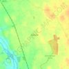
Carte topographique Leixlip
Cliquez sur la carte pour afficher l’altitude.
Leixlip
British publisher and cartographer Samuel Lewis mentions Confey Castle in the first volume of his 1837 work A Topographical Dictionary of Ireland. In it, he comments that Confey's (or Confoy as he spells it) population was 165, had formerly had a town and a castle of some importance, which were noticed by Camden. Of the tower's remains were a massive five-storey structure with turrets at the north and west angles; that at the north angle containing a winding staircase opening through pointed arches into each storey. The principal entrance was under a semicircular archway. In the war of 1688 the castle is said to have been strongly garrisoned, and to have sustained an attack.
À propos de cette carte

Nom : Carte topographique Leixlip, altitude, relief.
Altitude moyenne : 55 m
Altitude minimum : 21 m
Altitude maximum : 78 m
Autres cartes topographiques
Cliquez sur une carte pour visualiser sa topographie, son altitude et son relief.
Kildare Round Tower
A Topographical Dictionary of Ireland states "One of the ancient round towers stood here till 1807 when it was pulled down to make room for the belfry of the church".
Altitude moyenne : 100 m