
Carte topographique Oakdale
Carte interactive
Cliquez sur la carte pour afficher l’altitude.
Oakdale
Historically the area has been used for orchards and other agricultural uses. Some of the common soil types found in Oakdale are Delhi sand, Oakdale sandy loam, Hanford sandy loam, and Tujunga loamy sand. Oakdale is generally on level ground at an elevation of approximately 190 feet (58 m) above mean sea level. Drainage is generally to the northwest towards the Stanislaus River.
À propos de cette carte
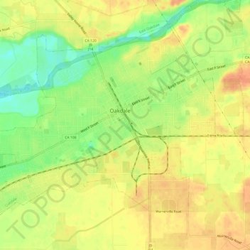
Nom : Carte topographique Oakdale, altitude, relief.
Altitude moyenne : 52 m
Altitude minimum : 26 m
Altitude maximum : 69 m
Autres cartes topographiques
Cliquez sur une carte pour visualiser sa topographie, son altitude et son relief.
San Joaquin River National Wildlife Refuge
United States > California > Stanislaus County
Altitude moyenne : 14 m