
Faire un don
Équipez-vous pour votre prochaine aventure :
En tant que Partenaire Amazon, ce site perçoit une commission sur les achats éligibles sans surcoût pour vous.
Carte topographique Wei-Assipu-tepui
Cliquez sur la carte pour afficher l’altitude.
Faire un don
Équipez-vous pour votre prochaine aventure :
En tant que Partenaire Amazon, ce site perçoit une commission sur les achats éligibles sans surcoût pour vous.
Wei-Assipu-tepui
Wei-Assipu-tepui has a maximum elevation of around 2,400 metres (7,870 ft). Its summit plateau is highly dissected and generally inclined south-southwest (towards the Brazilian side). The rocky summit is partially forested, with flowering plants of the genus Bonnetia featuring prominently. It also hosts a number of carnivorous plants, including Heliamphora glabra, Heliamphora nutans, and the natural hybrid between the two. The various rock cavities of Wei-Assipu-tepui are home to nesting colonies of white-collared swifts (Streptoprocne zonaris) and oilbirds (Steatornis caripensis). For the latter species, Wei-Assipu-tepui is the easternmost recorded locality in mainland South America, and the first known nesting site in Brazil. The mountain's summit supports a greater variety of herpetofauna than the less vegetated plateaus of nearby Roraima-tepui, Kukenán-tepui, Yuruaní-tepui, and Ilú-tepui. Day temperatures of 17 °C (63 °F) have been recorded on the summit plateau, falling to 12 °C (54 °F) overnight, with slightly lower values in the more sheltered caves.
Faire un don
Équipez-vous pour votre prochaine aventure :
En tant que Partenaire Amazon, ce site perçoit une commission sur les achats éligibles sans surcoût pour vous.
À propos de cette carte
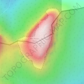
Nom : Carte topographique Wei-Assipu-tepui, altitude, relief.
Altitude moyenne : 1’760 m
Altitude minimum : 1’357 m
Altitude maximum : 2’277 m
Faire un don
Équipez-vous pour votre prochaine aventure :
En tant que Partenaire Amazon, ce site perçoit une commission sur les achats éligibles sans surcoût pour vous.