
Carte topographique Georgetown
Carte interactive
Cliquez sur la carte pour afficher l’altitude.
À propos de cette carte
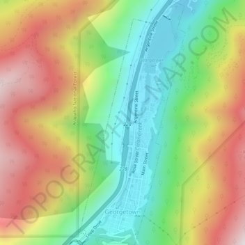
Nom : Carte topographique Georgetown, altitude, relief.
Altitude moyenne : 2’974 m
Altitude minimum : 2’557 m
Altitude maximum : 3’502 m
The town sits at an elevation of 8,530 feet (2,600 m) above sea level, nestled in the mountains near the upper end of the valley of Clear Creek in the mountains west of Denver along Interstate 70. Although population was only about 1,000 at the 2010 census, the town was a historic center of the mining industry in Colorado during the late 19th century, earning the nickname the "Silver Queen of Colorado". It has evolved into a lively historical summer tourist center today with many preserved structures from the heyday of the Colorado Silver Boom. The town stretches roughly north–south along Clear Creek, hemmed in by the mountains, with the historic downtown located at the southern (upper) end and modern development located at the northern (lower) end of town. Georgetown is now a part of the Denver–Aurora–Lakewood, CO Metropolitan Statistical Area and the Front Range Urban Corridor.
Autres cartes topographiques
Cliquez sur une carte pour visualiser sa topographie, son altitude et son relief.
Blue Valley
United States > Colorado > Clear Creek County
Blue Valley, Clear Creek County, Colorado, 80254, United States
Altitude moyenne : 2’966 m
Mount Blue Sky
United States > Colorado > Clear Creek County
Mount Blue Sky, Clear Creek County, Colorado, United States
Altitude moyenne : 4’006 m
Berthoud Falls
United States > Colorado > Clear Creek County
Berthoud Falls, Clear Creek County, Colorado, United States
Altitude moyenne : 3’357 m
Breckinridge Peak
United States > Colorado > Clear Creek County
Breckinridge Peak, Clear Creek County, Colorado, United States
Altitude moyenne : 3’637 m
Grays Peak
United States > Colorado > Clear Creek County
Grays Peak, Clear Creek County, Colorado, United States
Altitude moyenne : 3’914 m
Loveland Pass
United States > Colorado > Clear Creek County
Loveland Pass, Clear Creek County, Colorado, United States
Altitude moyenne : 3’639 m
St. Mary's
United States > Colorado > Clear Creek County
St. Mary's, Clear Creek County, Colorado, United States
Altitude moyenne : 3’281 m
Idaho Springs
United States > Colorado > Clear Creek County > Idaho Springs > Idaho Springs
Idaho Springs, Clear Creek County, Colorado, 80452, United States
Altitude moyenne : 2’624 m
Lawson
United States > Colorado > Clear Creek County > Lawson
Lawson, Clear Creek County, Colorado, 80436, United States
Altitude moyenne : 2’766 m
Idaho Springs
United States > Colorado > Clear Creek County
Idaho Springs, Clear Creek County, Colorado, 80452, United States
Altitude moyenne : 2’663 m