
Carte topographique Villahermosa del Río
Carte interactive
Cliquez sur la carte pour afficher l’altitude.
À propos de cette carte
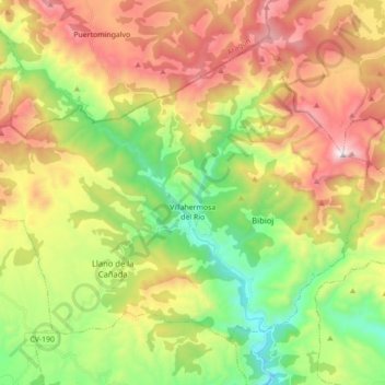
Nom : Carte topographique Villahermosa del Río, altitude, relief.
Altitude moyenne : 1’099 m
Altitude minimum : 567 m
Altitude maximum : 1’795 m
Autres cartes topographiques
Cliquez sur une carte pour visualiser sa topographie, son altitude et son relief.
El Contador
España > Comunidad Valenciana > Castellón > Villahermosa del Río
El Contador, Villahermosa del Río, El Alto Mijares, Castellón, Comunidad Valenciana, España
Altitude moyenne : 1’191 m
La Cambreta
España > Comunidad Valenciana > Castellón > Villahermosa del Río
La Cambreta, Villahermosa del Río, El Alto Mijares, Castellón, Comunidad Valenciana, 12124, España
Altitude moyenne : 760 m