
Carte topographique Harsil
Cliquez sur la carte pour afficher l’altitude.
À propos de cette carte
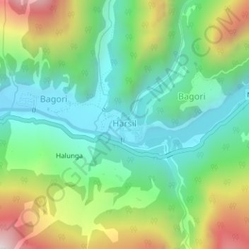
Nom : Carte topographique Harsil, altitude, relief.
Lieu : Harsil, Bhatwari, Uttarkashi, Uttarakhand, India (31.03390 78.74709 31.03965 78.75525)
Altitude moyenne : 2’761 m
Altitude minimum : 2’464 m
Altitude maximum : 3’350 m
Autres cartes topographiques
Cliquez sur une carte pour visualiser sa topographie, son altitude et son relief.
Uttarkashi
India > Uttarakhand > Bhatwari
It is the district headquarters of Uttarkashi district. Uttarkashi is situated on the banks of river Bhagirathi at an altitude of 1158 m above sea level. Uttarkashi is generally known as a holy town close to Rishikesh. It is located in the state of Uttarakhand in India. Uttarkashi is home to a number of…
Altitude moyenne : 1’619 m
Gomukh, Ice Cave
India > Uttarakhand > Bhatwari
Around the snout, nature presents a wild topography. There are boulders scattered here and there with some pieces of broken snow, along with the hard clayey snow of the glacier.
Altitude moyenne : 4’286 m
Sudarshan Parbat
India > Uttarakhand > Bhatwari
Sudarshan Parbat is a mountain of the Garhwal Himalaya in Uttarakhand India.The elevation of Sudarshan Parbat is 6,529 metres (21,421 ft) and its prominence is 456 metres (1,496 ft). It is joint 87th highest located entirely within the Uttrakhand. Nanda Devi, is the highest mountain in this category. Sudarshan…
Altitude moyenne : 5’792 m